
Haz una donación
Equípate para tu próxima aventura:
Como asociado de Amazon, este sitio gana comisiones por las compras que califican, sin ningún costo adicional para usted.
Mapa topográfico Stewart Island
Haga clic en el mapa para ver la altitud.
Haz una donación
Equípate para tu próxima aventura:
Como asociado de Amazon, este sitio gana comisiones por las compras que califican, sin ningún costo adicional para usted.
Stewart Island
Although the clay soil is not very fertile, the high rainfall and warm weather mean that the island is densely forested throughout. Native plants include the world's southernmost dense forest of podocarps (southern conifers) and hardwoods such as rātā and kāmahi in the lowland areas with mānuka shrubland at higher elevations. The trees are thought to have become established here since the last ice age from seeds brought across the strait by seabirds, which would explain why the beech trees that are so common in New Zealand, but whose seeds are dispersed by the wind rather than birds, are not found on Stewart Island.
Haz una donación
Equípate para tu próxima aventura:
Como asociado de Amazon, este sitio gana comisiones por las compras que califican, sin ningún costo adicional para usted.
Acerca de este mapa
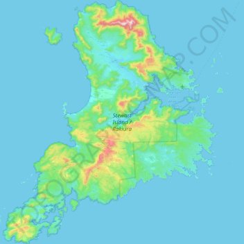
Nombre: Mapa topográfico Stewart Island, altitud, relieve.
Lugar: Stewart Island, Southland, New Zealand (-47.29000 167.44721 -46.68343 168.22927)
Altitud media: 63 m
Altitud mínima: -2 m
Altitud máxima: 967 m
Haz una donación
Equípate para tu próxima aventura:
Como asociado de Amazon, este sitio gana comisiones por las compras que califican, sin ningún costo adicional para usted.
Otros mapas topográficos
Haga clic en un mapa para ver su topografía, su altitud y su relieve.
Haz una donación
Equípate para tu próxima aventura:
Como asociado de Amazon, este sitio gana comisiones por las compras que califican, sin ningún costo adicional para usted.
Roslyn Bush
New Zealand > Southland > Southland District > Waihopai Toetoe Community
Altitud media: 29 m
Nightcaps
New Zealand > Southland > Southland District > Wallace Takitimu Community
Altitud media: 183 m
Clifden
New Zealand > Southland > Southland District > Tuatapere Te Waewae Community
Altitud media: 70 m
Haz una donación
Equípate para tu próxima aventura:
Como asociado de Amazon, este sitio gana comisiones por las compras que califican, sin ningún costo adicional para usted.
Pukemaori
New Zealand > Southland > Southland District > Tuatapere Te Waewae Community
Altitud media: 124 m
Haz una donación
Equípate para tu próxima aventura:
Como asociado de Amazon, este sitio gana comisiones por las compras que califican, sin ningún costo adicional para usted.
Haz una donación
Equípate para tu próxima aventura:
Como asociado de Amazon, este sitio gana comisiones por las compras que califican, sin ningún costo adicional para usted.
Otahu Flat
New Zealand > Southland > Southland District > Tuatapere Te Waewae Community
Altitud media: 90 m
Tūātapere
New Zealand > Southland > Southland District > Tuatapere Te Waewae Community
Altitud media: 41 m
Haz una donación
Equípate para tu próxima aventura:
Como asociado de Amazon, este sitio gana comisiones por las compras que califican, sin ningún costo adicional para usted.
Mount Tūtoko
New Zealand > Southland > Southland District > Fiordland Community
Altitud media: 1.892 m
Mount Anglem / Hananui
New Zealand > Southland > Southland District > Stewart Island / Rakiura Community
Mount Anglem / Hananui is the highest point on New Zealand's Stewart Island / Rakiura. It is located 20 kilometres (12 mi) northwest of Oban, close to the island's north coast, and rises to an elevation of 980 metres (3,215 ft) above sea level. Following the passage of the Ngāi Tahu Claims Settlement Act…
Altitud media: 668 m
Mount Christina
New Zealand > Southland > Southland District > Fiordland Community
Altitud media: 1.574 m
Haz una donación
Equípate para tu próxima aventura:
Como asociado de Amazon, este sitio gana comisiones por las compras que califican, sin ningún costo adicional para usted.
Takitimu Mountains
New Zealand > Southland > Southland District > Wallace Takitimu Community
Altitud media: 828 m
Haz una donación
Equípate para tu próxima aventura:
Como asociado de Amazon, este sitio gana comisiones por las compras que califican, sin ningún costo adicional para usted.
Darran Mountains
New Zealand > Southland > Southland District > Fiordland Community
Altitud media: 911 m
Skippers Range
New Zealand > Southland > Southland District > Fiordland Community
Altitud media: 595 m
Te Rau / Garvie Mountains
New Zealand > Southland > Southland District > Cromwell Community
Altitud media: 1.393 m
Haz una donación
Equípate para tu próxima aventura:
Como asociado de Amazon, este sitio gana comisiones por las compras que califican, sin ningún costo adicional para usted.
Wick Mountains
New Zealand > Southland > Southland District > Fiordland Community
Altitud media: 1.185 m
Tapuae-o-Uenuku / Hector Mountains
New Zealand > Southland > Queenstown-Lakes District
The foothills of the Hector Mountains were also significant to early Pākehā. The range was largely affected by the Otago gold rush of the 1860s, which saw miners flock to the Nevis in search of gold and a small town established in the foothills of the range. Sluicing sites are found along the eastern end of…
Altitud media: 1.087 m
Haz una donación
Equípate para tu próxima aventura:
Como asociado de Amazon, este sitio gana comisiones por las compras que califican, sin ningún costo adicional para usted.
Waikawa River
New Zealand > Southland > Southland District > Waihopai Toetoe Community
Altitud media: 134 m
Haz una donación
Equípate para tu próxima aventura:
Como asociado de Amazon, este sitio gana comisiones por las compras que califican, sin ningún costo adicional para usted.
Haz una donación
Equípate para tu próxima aventura:
Como asociado de Amazon, este sitio gana comisiones por las compras que califican, sin ningún costo adicional para usted.
Pembroke Glacier
New Zealand > Southland > Southland District > Fiordland Community
Altitud media: 1.211 m
Haz una donación
Equípate para tu próxima aventura:
Como asociado de Amazon, este sitio gana comisiones por las compras que califican, sin ningún costo adicional para usted.
Oban
New Zealand > Southland > Southland District > Stewart Island / Rakiura Community
Altitud media: 23 m
Mount Elliot
New Zealand > Southland > Southland District > Fiordland Community
Altitud media: 1.110 m
Waimānu / Stirling Falls
New Zealand > Southland > Southland District > Fiordland Community
Altitud media: 423 m
Haz una donación
Equípate para tu próxima aventura:
Como asociado de Amazon, este sitio gana comisiones por las compras que califican, sin ningún costo adicional para usted.
Nightcaps
New Zealand > Southland > Southland District > Wallace Takitimu Community
Altitud media: 183 m
Lake Innes
New Zealand > Southland > Southland District > Tuatapere Te Waewae Community
Altitud media: 223 m
Haz una donación
Equípate para tu próxima aventura:
Como asociado de Amazon, este sitio gana comisiones por las compras que califican, sin ningún costo adicional para usted.
Oban
New Zealand > Southland > Southland District > Stewart Island / Rakiura Community
Altitud media: 23 m
Hineteawa / Bowen Falls
New Zealand > Southland > Southland District > Fiordland Community
Altitud media: 232 m
Haz una donación
Equípate para tu próxima aventura:
Como asociado de Amazon, este sitio gana comisiones por las compras que califican, sin ningún costo adicional para usted.
Island Hill
New Zealand > Southland > Southland District > Stewart Island / Rakiura Community
Altitud media: 50 m
Twin Sisters
New Zealand > Southland > Southland District > Fiordland Community
Altitud media: 1.039 m
Haz una donación
Equípate para tu próxima aventura:
Como asociado de Amazon, este sitio gana comisiones por las compras que califican, sin ningún costo adicional para usted.
Pearl Harbour
New Zealand > Southland > Southland District > Fiordland Community > Manapouri
Altitud media: 212 m
Haz una donación
Equípate para tu próxima aventura:
Como asociado de Amazon, este sitio gana comisiones por las compras que califican, sin ningún costo adicional para usted.
Merrivale
New Zealand > Southland > Southland District > Tuatapere Te Waewae Community
Altitud media: 192 m
Sutherland Falls
New Zealand > Southland > Southland District > Fiordland Community
Altitud media: 1.006 m
Haz una donación
Equípate para tu próxima aventura:
Como asociado de Amazon, este sitio gana comisiones por las compras que califican, sin ningún costo adicional para usted.
White Peak
New Zealand > Southland > Southland District > Tuatapere Te Waewae Community
Altitud media: 1.153 m
Blackmount
New Zealand > Southland > Southland District > Tuatapere Te Waewae Community > Blackmount
Altitud media: 170 m
Haz una donación
Equípate para tu próxima aventura:
Como asociado de Amazon, este sitio gana comisiones por las compras que califican, sin ningún costo adicional para usted.
Waikawa
New Zealand > Southland > Southland District > Waihopai Toetoe Community > Waikawa
Altitud media: 39 m
Haz una donación
Equípate para tu próxima aventura:
Como asociado de Amazon, este sitio gana comisiones por las compras que califican, sin ningún costo adicional para usted.
Mount Makere
New Zealand > Southland > Southland District > Fiordland Community
Altitud media: 1.433 m
Turner Falls
New Zealand > Southland > Southland District > Fiordland Community
Altitud media: 1.335 m
The Downs
New Zealand > Southland > Southland District > Tuatapere Te Waewae Community
Altitud media: 34 m
Haz una donación
Equípate para tu próxima aventura:
Como asociado de Amazon, este sitio gana comisiones por las compras que califican, sin ningún costo adicional para usted.