
Haz una donación
Equípate para tu próxima aventura:
Como asociado de Amazon, este sitio gana comisiones por las compras que califican, sin ningún costo adicional para usted.
Mapa topográfico Fredericton
Haga clic en el mapa para ver la altitud.
Haz una donación
Equípate para tu próxima aventura:
Como asociado de Amazon, este sitio gana comisiones por las compras que califican, sin ningún costo adicional para usted.
Fredericton
At an altitude of about 17 m (56 ft) above sea level, Fredericton is nestled in the Pennsylvanian Basin. It differs markedly from the geologically older parts of the province. There are prominently two distinct areas in the region that are divided around the area of Wilsey Road, in the east end of the city. In the west side, the bedrock underneath the earth is topographically dominant, whereas the other is controlled by Pleistocene and recent deposits leading to the rivers (resulting in the area being shallow and wide). Fredericton and its surroundings are rich in water resources, which, coupled with highly arable soil, make the Fredericton region ideal for agriculture. The Saint John River and one of its major tributaries, the Nashwaak River, come together in Fredericton. The uninhabited parts of the city are heavily forested.
Haz una donación
Equípate para tu próxima aventura:
Como asociado de Amazon, este sitio gana comisiones por las compras que califican, sin ningún costo adicional para usted.
Acerca de este mapa
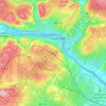
Nombre: Mapa topográfico Fredericton, altitud, relieve.
Altitud media: 72 m
Altitud mínima: -2 m
Altitud máxima: 196 m
Haz una donación
Equípate para tu próxima aventura:
Como asociado de Amazon, este sitio gana comisiones por las compras que califican, sin ningún costo adicional para usted.