
Mapa topográfico Sitapur
Mapa interactivo
Haga clic en el mapa para ver la altitud.
Acerca de este mapa
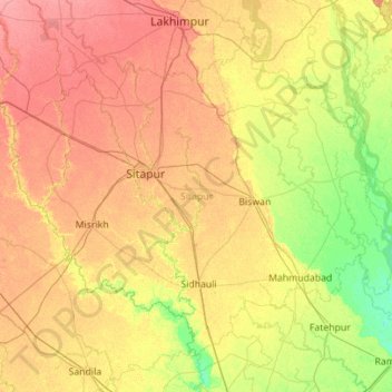
Nombre: Mapa topográfico Sitapur, altitud, relieve.
Lugar: Sitapur, Uttar Pradesh, India (27.10146 80.29944 27.90762 81.41530)
Altitud media: 131 m
Altitud mínima: 108 m
Altitud máxima: 158 m
Sitapur is located at 27.57°N 80.68°E. It test has an average elevation of 138 meters (452 feet). It is located in the Gangetic Plain, with elevations ranging from 150 m above sea level in the north-west to 100 m in the south-east. It is intersected by numerous streams and ravines and contains many shallow ponds and natural reservoirs, which overflow during the rainy seasons, but become dry, in some places, in the hot season. Except in the eastern portion, which lies in the doabs between the Kewani and the Chauka, and the Ghaghra and the Chauka rivers, the soil is semi arid. Even this moist tract is interspersed with patches of land covered with saline efflorescence called reh.
Otros mapas topográficos
Haga clic en un mapa para ver su topografía, su altitud y su relieve.
Kanpur Dehat District
Kanpur Dehat District, Uttar Pradesh, India
Altitud media: 132 m
Ganges
India > Uttar Pradesh > Ghazipur
Ganges, Ghazipur, Uttar Pradesh, 233001, India
Altitud media: 1.626 m
Beel Akbarpur
India > Uttar Pradesh > Beel Akbarpur
Beel Akbarpur, Ghaziabad, Uttar Pradesh, 201314, India
Altitud media: 208 m