
Haz una donación
Equípate para tu próxima aventura:
Como asociado de Amazon, este sitio gana comisiones por las compras que califican, sin ningún costo adicional para usted.
Mapa topográfico Josie
Haga clic en el mapa para ver la altitud.
Haz una donación
Equípate para tu próxima aventura:
Como asociado de Amazon, este sitio gana comisiones por las compras que califican, sin ningún costo adicional para usted.
Acerca de este mapa
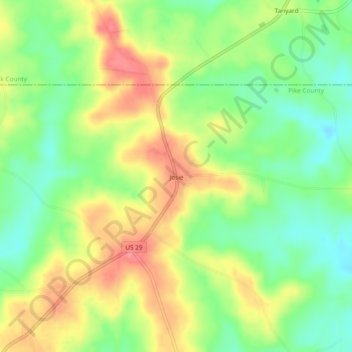
Nombre: Mapa topográfico Josie, altitud, relieve.
Lugar: Josie, Pike County, Alabama, United States (31.84988 -85.73883 31.88988 -85.69883)
Altitud media: 149 m
Altitud mínima: 111 m
Altitud máxima: 192 m
Haz una donación
Equípate para tu próxima aventura:
Como asociado de Amazon, este sitio gana comisiones por las compras que califican, sin ningún costo adicional para usted.
Otros mapas topográficos
Haga clic en un mapa para ver su topografía, su altitud y su relieve.
Troy
United States > Alabama > Pike County
Troy is located at 31°48′32″N 85°58′12″W / 31.80889°N 85.97000°W / 31.80889; -85.97000 (31.808768, −85.969951). It is in the East Gulf Coastal Plains region of Alabama. It is located along the Troy Cuesta ridge, which runs across the state from east to west and is the boundary that…
Altitud media: 131 m
Troy
United States > Alabama > Pike County
Troy is in the East Gulf Coastal Plains region of Alabama. It is located along the Troy Cuesta ridge, which runs across the state from east to west and is the boundary that separates the Chunnenuggee Hills and Southern Red Hills geographical boundaries. Elevations commonly reach 400 feet (120 m) in these hills…
Altitud media: 131 m
Haz una donación
Equípate para tu próxima aventura:
Como asociado de Amazon, este sitio gana comisiones por las compras que califican, sin ningún costo adicional para usted.