
Haz una donación
Equípate para tu próxima aventura:
Como asociado de Amazon, este sitio gana comisiones por las compras que califican, sin ningún costo adicional para usted.
Mapa topográfico Ficulle
Haga clic en el mapa para ver la altitud.
Haz una donación
Equípate para tu próxima aventura:
Como asociado de Amazon, este sitio gana comisiones por las compras que califican, sin ningún costo adicional para usted.
Acerca de este mapa
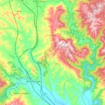
Nombre: Mapa topográfico Ficulle, altitud, relieve.
Lugar: Ficulle, Terni, Umbria, 05016, Italy (42.75706 12.01112 42.87611 12.13245)
Altitud media: 293 m
Altitud mínima: 127 m
Altitud máxima: 550 m
Haz una donación
Equípate para tu próxima aventura:
Como asociado de Amazon, este sitio gana comisiones por las compras que califican, sin ningún costo adicional para usted.
Otros mapas topográficos
Haga clic en un mapa para ver su topografía, su altitud y su relieve.
Cesi
Italy > Umbria > Terni > Terni
Cesi is a frazione of the Italian comune of Terni, in the province of Terni, southern Umbria, Italy. The small borgo, which retains its late-medieval aspect, set among olive groves, lies "stretched out lengthwise along a narrow contour on the slopes of M. Torre Maggiore," about 18 km north of Terni at an…
Altitud media: 447 m
Haz una donación
Equípate para tu próxima aventura:
Como asociado de Amazon, este sitio gana comisiones por las compras que califican, sin ningún costo adicional para usted.