
Haz una donación
Equípate para tu próxima aventura:
Como asociado de Amazon, este sitio gana comisiones por las compras que califican, sin ningún costo adicional para usted.
Mapa topográfico Ansonia
Haga clic en el mapa para ver la altitud.
Haz una donación
Equípate para tu próxima aventura:
Como asociado de Amazon, este sitio gana comisiones por las compras que califican, sin ningún costo adicional para usted.
Acerca de este mapa
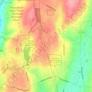
Nombre: Mapa topográfico Ansonia, altitud, relieve.
Altitud media: 111 m
Altitud mínima: 43 m
Altitud máxima: 162 m
Haz una donación
Equípate para tu próxima aventura:
Como asociado de Amazon, este sitio gana comisiones por las compras que califican, sin ningún costo adicional para usted.
Otros mapas topográficos
Haga clic en un mapa para ver su topografía, su altitud y su relieve.
Haz una donación
Equípate para tu próxima aventura:
Como asociado de Amazon, este sitio gana comisiones por las compras que califican, sin ningún costo adicional para usted.
North Haven
United States > Connecticut > South Central Connecticut Planning Region
Altitud media: 38 m
Sea Bluff
United States > Connecticut > South Central Connecticut Planning Region > West Haven > West Shore
Altitud media: 14 m
Haz una donación
Equípate para tu próxima aventura:
Como asociado de Amazon, este sitio gana comisiones por las compras que califican, sin ningún costo adicional para usted.
New Haven County
United States > Connecticut > South Central Connecticut Planning Region
The terrain is mostly flat near the coast, with low hills defining the rest of the area, rising significantly only in the north of the county. The highest elevation is close to the northernmost point in the county, found at two areas of approximately 1,050 feet (320 m) above sea level in the town of Wolcott.…
Altitud media: 87 m
Indian Neck
United States > Connecticut > South Central Connecticut Planning Region > Branford
Altitud media: 4 m
Haz una donación
Equípate para tu próxima aventura:
Como asociado de Amazon, este sitio gana comisiones por las compras que califican, sin ningún costo adicional para usted.
Woodbridge
United States > Connecticut > South Central Connecticut Planning Region
Altitud media: 96 m
Northford
United States > Connecticut > South Central Connecticut Planning Region > North Branford
Altitud media: 71 m
Wallingford
United States > Connecticut > South Central Connecticut Planning Region
Altitud media: 72 m
North Branford
United States > Connecticut > South Central Connecticut Planning Region
Altitud media: 68 m
Haz una donación
Equípate para tu próxima aventura:
Como asociado de Amazon, este sitio gana comisiones por las compras que califican, sin ningún costo adicional para usted.
West Haven
United States > Connecticut > South Central Connecticut Planning Region
Altitud media: 16 m
Borough of Woodmont
United States > Connecticut > South Central Connecticut Planning Region > Milford
A majority of the borough land mass is safely above sea level. However, it does have a few low elevation areas which are subject to flooding during very heavy storm situations (Hurricanes). The most recent, circa 2013 FEMA generated flood map is shown at the right, with the borough border roughly outlined in…
Altitud media: 3 m
Momauguin
United States > Connecticut > South Central Connecticut Planning Region > East Haven
Altitud media: 3 m
Indian Cave
United States > Connecticut > South Central Connecticut Planning Region > Guilford
Altitud media: 25 m
Haz una donación
Equípate para tu próxima aventura:
Como asociado de Amazon, este sitio gana comisiones por las compras que califican, sin ningún costo adicional para usted.
North Madison
United States > Connecticut > South Central Connecticut Planning Region > Madison
Altitud media: 91 m
Nut Plains
United States > Connecticut > South Central Connecticut Planning Region > Guilford
Altitud media: 35 m
Fort Trumbull
United States > Connecticut > South Central Connecticut Planning Region > Milford
Altitud media: 7 m
Haz una donación
Equípate para tu próxima aventura:
Como asociado de Amazon, este sitio gana comisiones por las compras que califican, sin ningún costo adicional para usted.
West Shore
United States > Connecticut > South Central Connecticut Planning Region > West Haven
Altitud media: 9 m
North Haven Bridge
United States > Connecticut > South Central Connecticut Planning Region > North Haven
Altitud media: 22 m
Jeffrey Point
United States > Connecticut > South Central Connecticut Planning Region > Branford
Altitud media: 1 m
Haz una donación
Equípate para tu próxima aventura:
Como asociado de Amazon, este sitio gana comisiones por las compras que califican, sin ningún costo adicional para usted.
West Shore
United States > Connecticut > South Central Connecticut Planning Region > West Haven
Altitud media: 9 m
Sleeping Giant State Park
United States > Connecticut > South Central Connecticut Planning Region > Hamden
Sleeping Giant (also known as the Blue Hills and Mount Carmel), (Hobbomock in Quinnipiac), is a rugged traprock mountain with a high point of 739 feet (225 m), located eight miles (13 km) north of New Haven, Connecticut. A prominent landscape feature visible for miles, the Sleeping Giant receives its name from…
Altitud media: 79 m
Haz una donación
Equípate para tu próxima aventura:
Como asociado de Amazon, este sitio gana comisiones por las compras que califican, sin ningún costo adicional para usted.
South End Point
United States > Connecticut > South Central Connecticut Planning Region > East Haven > Momauguin
Altitud media: 2 m
West Haven
United States > Connecticut > South Central Connecticut Planning Region
Altitud media: 16 m
Forest Heights
United States > Connecticut > South Central Connecticut Planning Region > Milford
Altitud media: 19 m
Haz una donación
Equípate para tu próxima aventura:
Como asociado de Amazon, este sitio gana comisiones por las compras que califican, sin ningún costo adicional para usted.
Silver Beach
United States > Connecticut > South Central Connecticut Planning Region > Milford > Fort Trumbull
Altitud media: 5 m
Branford Hills
United States > Connecticut > South Central Connecticut Planning Region > Branford
Altitud media: 12 m
North Haven
United States > Connecticut > South Central Connecticut Planning Region
Altitud media: 38 m
East Peak
United States > Connecticut > South Central Connecticut Planning Region > Meriden
Altitud media: 154 m
Haz una donación
Equípate para tu próxima aventura:
Como asociado de Amazon, este sitio gana comisiones por las compras que califican, sin ningún costo adicional para usted.
New Haven County
United States > Connecticut > South Central Connecticut Planning Region
The terrain is mostly flat near the coast, with low hills defining the rest of the area, rising significantly only in the north of the county. The highest elevation is close to the northernmost point in the county, found at two areas of approximately 1,050 feet (320 m) above sea level in the town of Wolcott.…
Altitud media: 87 m
West Haven
United States > Connecticut > South Central Connecticut Planning Region
Altitud media: 16 m
Haz una donación
Equípate para tu próxima aventura:
Como asociado de Amazon, este sitio gana comisiones por las compras que califican, sin ningún costo adicional para usted.
Momauguin
United States > Connecticut > South Central Connecticut Planning Region > East Haven
Altitud media: 3 m
Silver Beach
United States > Connecticut > South Central Connecticut Planning Region > Milford
Altitud media: 5 m
Nut Plains
United States > Connecticut > South Central Connecticut Planning Region > Guilford
Altitud media: 35 m
Woodbridge
United States > Connecticut > South Central Connecticut Planning Region
Altitud media: 96 m
Haz una donación
Equípate para tu próxima aventura:
Como asociado de Amazon, este sitio gana comisiones por las compras que califican, sin ningún costo adicional para usted.
Wallingford
United States > Connecticut > South Central Connecticut Planning Region
Altitud media: 72 m
South Meriden
United States > Connecticut > South Central Connecticut Planning Region > Meriden
Altitud media: 55 m
Bayview
United States > Connecticut > South Central Connecticut Planning Region > Milford
Altitud media: 5 m
Haz una donación
Equípate para tu próxima aventura:
Como asociado de Amazon, este sitio gana comisiones por las compras que califican, sin ningún costo adicional para usted.
Brightview
United States > Connecticut > South Central Connecticut Planning Region > New Haven
Altitud media: 5 m
Fort Trumbull
United States > Connecticut > South Central Connecticut Planning Region > Milford
Altitud media: 7 m
Haz una donación
Equípate para tu próxima aventura:
Como asociado de Amazon, este sitio gana comisiones por las compras que califican, sin ningún costo adicional para usted.
Sea Bluff
United States > Connecticut > South Central Connecticut Planning Region > West Haven > West Shore
Altitud media: 14 m
Mount Carmel Center
United States > Connecticut > South Central Connecticut Planning Region > Hamden
Altitud media: 79 m
Morningside
United States > Connecticut > South Central Connecticut Planning Region > Milford
Altitud media: 5 m
Haz una donación
Equípate para tu próxima aventura:
Como asociado de Amazon, este sitio gana comisiones por las compras que califican, sin ningún costo adicional para usted.
East River
United States > Connecticut > South Central Connecticut Planning Region > Madison
Altitud media: 9 m
Big Indian
United States > Connecticut > South Central Connecticut Planning Region > Guilford
Altitud media: 41 m
Sunset Hill
United States > Connecticut > South Central Connecticut Planning Region > Branford
Altitud media: 12 m
Sea Bluff
United States > Connecticut > South Central Connecticut Planning Region > West Haven > West Shore
Altitud media: 14 m
Haz una donación
Equípate para tu próxima aventura:
Como asociado de Amazon, este sitio gana comisiones por las compras que califican, sin ningún costo adicional para usted.
Clark Hill
United States > Connecticut > South Central Connecticut Planning Region > Milford
Altitud media: 11 m
Peter's Rock
United States > Connecticut > South Central Connecticut Planning Region > North Haven
Altitud media: 38 m
West Haven
United States > Connecticut > South Central Connecticut Planning Region
Altitud media: 16 m
Haz una donación
Equípate para tu próxima aventura:
Como asociado de Amazon, este sitio gana comisiones por las compras que califican, sin ningún costo adicional para usted.
Quinnipiac
United States > Connecticut > South Central Connecticut Planning Region > Wallingford
Altitud media: 31 m
Fair Haven East
United States > Connecticut > South Central Connecticut Planning Region > New Haven
Altitud media: 14 m
Haz una donación
Equípate para tu próxima aventura:
Como asociado de Amazon, este sitio gana comisiones por las compras que califican, sin ningún costo adicional para usted.
North Branford
United States > Connecticut > South Central Connecticut Planning Region
Altitud media: 68 m
Allingtown
United States > Connecticut > South Central Connecticut Planning Region > West Haven
Altitud media: 26 m
Haz una donación
Equípate para tu próxima aventura:
Como asociado de Amazon, este sitio gana comisiones por las compras que califican, sin ningún costo adicional para usted.