
Mapa topográfico Brinkum
Mapa interactivo
Haga clic en el mapa para ver la altitud.
Acerca de este mapa
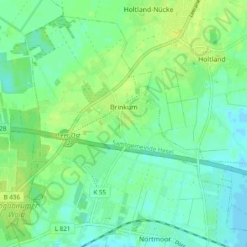
Nombre: Mapa topográfico Brinkum, altitud, relieve.
Altitud media: 7 m
Altitud mínima: -2 m
Altitud máxima: 14 m
Otros mapas topográficos
Haga clic en un mapa para ver su topografía, su altitud y su relieve.
Veenhusen
Germany > Lower Saxony > Landkreis Leer
Veenhusen, Moormerland, Landkreis Leer, Lower Saxony, 26802, Germany
Altitud media: 4 m
Schatteburg
Germany > Lower Saxony > Landkreis Leer > Backemoor > Schatteburg
Schatteburg, Backemoor, Rhauderfehn, Landkreis Leer, Lower Saxony, Germany
Altitud media: 3 m
Borkum
Germany > Lower Saxony > Landkreis Leer > Borkum
Borkum, Landkreis Leer, Lower Saxony, Germany
Altitud media: 0 m