
Mapa topográfico Gifford Pinchot National Forest
Mapa interactivo
Haga clic en el mapa para ver la altitud.
Acerca de este mapa
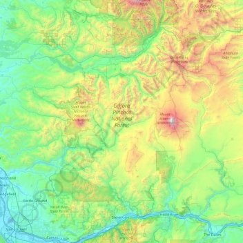
Nombre: Mapa topográfico Gifford Pinchot National Forest, altitud, relieve.
Altitud media: 769 m
Altitud mínima: -1 m
Altitud máxima: 3.703 m
Gifford Pinchot National Forest is located in a mountainous region approximately between Mount St. Helens to the west, Mount Adams to the east, Mount Rainier National Park to the north, and the Columbia River to the south. This region of Southwest Washington is noted for its complex topography and volcanic geology. About 65 percent of the forest acreage is located in Skamania County. In descending order of land area the others are Lewis, Yakima, Cowlitz, and Klickitat counties.
Otros mapas topográficos
Haga clic en un mapa para ver su topografía, su altitud y su relieve.
Spirit Lake
United States > Washington > Skamania County
Spirit Lake, Skamania County, Washington, United States
Altitud media: 1.144 m
Mount Saint Helens
United States > Washington > Skamania County
Mount Saint Helens, Skamania County, Washington, United States
Altitud media: 2.096 m