
Mapa topográfico Top Camp
Haga clic en el mapa para ver la altitud.
Top Camp
Top Camp is 9 kilometres (6 mi) from the Toowoomba city centre via the New England Highway. It is immediately to the west of the Great Dividing Range and is at an elevation of 580 to 630 metres (1,900 to 2,070 ft).The highway passes through the eastern part of the locality from north (Kearney Springs) to south (Hodgson Vale).
Acerca de este mapa
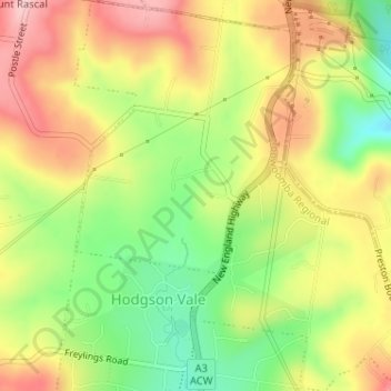
Nombre: Mapa topográfico Top Camp, altitud, relieve.
Altitud media: 604 m
Altitud mínima: 507 m
Altitud máxima: 696 m
Otros mapas topográficos
Haga clic en un mapa para ver su topografía, su altitud y su relieve.