
Mapa topográfico Alexandria
Mapa interactivo
Haga clic en el mapa para ver la altitud.
Acerca de este mapa
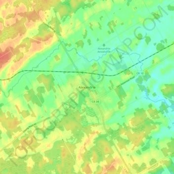
Nombre: Mapa topográfico Alexandria, altitud, relieve.
Altitud media: 84 m
Altitud mínima: 64 m
Altitud máxima: 108 m
Otros mapas topográficos
Haga clic en un mapa para ver su topografía, su altitud y su relieve.
Apple Hill
Canada > Ontario > Stormont, Dundas and Glengarry Counties > North Glengarry
Apple Hill, North Glengarry, Stormont, Dundas and Glengarry Counties, Eastern Ontario, Ontario, K0C 1B0, Canada
Altitud media: 90 m
Dalkeith
Canada > Ontario > Stormont, Dundas and Glengarry Counties > North Glengarry
Dalkeith, North Glengarry, Stormont, Dundas and Glengarry Counties, Eastern Ontario, Ontario, Canada
Altitud media: 70 m
Dunvegan
Canada > Ontario > Stormont, Dundas and Glengarry Counties > North Glengarry
Dunvegan, North Glengarry, Stormont, Dundas and Glengarry Counties, Eastern Ontario, Ontario, Canada
Altitud media: 87 m
Maxville
Canada > Ontario > Stormont, Dundas and Glengarry Counties > North Glengarry
Maxville, North Glengarry, Stormont, Dundas and Glengarry Counties, Eastern Ontario, Ontario, K0C 1T0, Canada
Altitud media: 100 m