
Mapa topográfico Gorlice
Mapa interactivo
Haga clic en el mapa para ver la altitud.
Acerca de este mapa
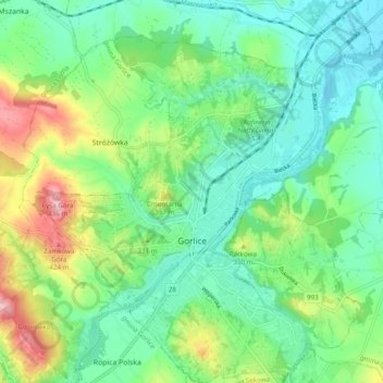
Nombre: Mapa topográfico Gorlice, altitud, relieve.
Lugar: Gorlice, Gorlice County, Lesser Poland Voivodeship, Poland (49.63483 21.11896 49.69780 21.21293)
Altitud media: 315 m
Altitud mínima: 264 m
Altitud máxima: 435 m
The city lies between the Ropa and Sękówka river valleys, surrounded by several mountain ranges of the Carpathian Mountains, namely their part called Beskid Niski (Low Beskids) massive. It is located in the heartland of the Doły (Pits), and its average elevation above sea level is 380 metres (1,247 feet), although there are some more considerable hills located within the confines of the city. The city is nowadays situated in a heavily populated region 14.6 miles (23.5 kilometres) from Jasło, 21.2 mi (34.1 km) from Nowy Sącz, 25.5 mi (41.0 km) from Tarnów, and 62.6 mi (100.7 km) from Kraków. Gorlice is known in Ukrainian: as Horlytsi, Горлиці; in Yiddish: גאָרליץ as Gorlitz; and in German: as Görlitz.
Otros mapas topográficos
Haga clic en un mapa para ver su topografía, su altitud y su relieve.
Bystra
Poland > Lesser Poland Voivodeship > Gorlice County
Bystra, gmina Gorlice, Gorlice County, Lesser Poland Voivodeship, 38-317, Poland
Altitud media: 432 m