
Mapa topográfico Seligman
Mapa interactivo
Haga clic en el mapa para ver la altitud.
Acerca de este mapa
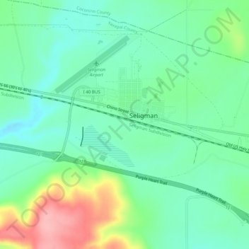
Nombre: Mapa topográfico Seligman, altitud, relieve.
Lugar: Seligman, Yavapai County, Arizona, 86337, United States (35.28688 -112.91631 35.36688 -112.83631)
Altitud media: 1.617 m
Altitud mínima: 1.563 m
Altitud máxima: 1.817 m
Seligman is located at 35°19′42″N 112°52′27″W / 35.32833°N 112.87417°W / 35.32833; -112.87417 (35.328199, −112.874303), at 5,240 feet (1,600 m) in elevation, alongside the Big Chino Wash, in a northern section of Chino Valley. The wash is a major tributary of the Verde River. Seligman is a popular stopping point along Historic U.S. Route 66.