
Mapa topográfico Çorum
Mapa interactivo
Haga clic en el mapa para ver la altitud.
Acerca de este mapa
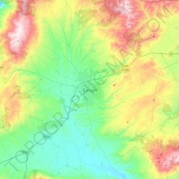
Nombre: Mapa topográfico Çorum, altitud, relieve.
Lugar: Çorum, Çorum merkez, Çorum, Black Sea Region, 19100, Turkey (40.38915 34.80025 40.70915 35.12025)
Altitud media: 1.044 m
Altitud mínima: 674 m
Altitud máxima: 1.783 m
Çorum (Turkish pronunciation: ; Medieval Greek: Ευχάνεια, romanized: Euchaneia) is a northern Anatolian city that is the capital of the Çorum Province of Turkey. Çorum is located inland in the central Black Sea Region of Turkey, and is approximately 244 km (152 mi) from Ankara and 608 km (378 mi) from Istanbul. The city has an elevation of 801 m (2,628 ft) above sea level, a surface area of 12,820 km2 (4,950 sq mi), and as of the 2016 census, a population of 237,000.