
Mapa topográfico Bullskin Township
Mapa interactivo
Haga clic en el mapa para ver la altitud.
Bullskin Township
Bullskin Township is in northeastern Fayette County, bordered to the north by Westmoreland County. The eastern border of the township follows the crest of Chestnut Ridge, reaching elevations of 2,340 feet (710 m) above sea level. According to the United States Census Bureau, the township has a total area of 43.64 square miles (113.02 km2), of which 43.53 square miles (112.75 km2) is land and 0.11 square miles (0.272 km2), or 0.24%, is water.
Acerca de este mapa
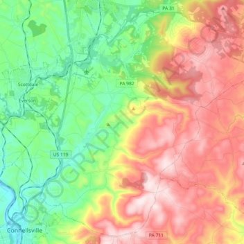
Nombre: Mapa topográfico Bullskin Township, altitud, relieve.
Altitud media: 458 m
Altitud mínima: 258 m
Altitud máxima: 713 m
Otros mapas topográficos
Haga clic en un mapa para ver su topografía, su altitud y su relieve.