
Haz una donación
Equípate para tu próxima aventura:
Como asociado de Amazon, este sitio gana comisiones por las compras que califican, sin ningún costo adicional para usted.
Mapa topográfico Truro
Haga clic en el mapa para ver la altitud.
Haz una donación
Equípate para tu próxima aventura:
Como asociado de Amazon, este sitio gana comisiones por las compras que califican, sin ningún costo adicional para usted.
Truro
Truro (postcode 5356, altitude 311m) is a town in South Australia, 80 km northeast of Adelaide. It is situated in an agricultural and pastoral district on the Sturt Highway, east of the Barossa Valley, where the highway crosses somewhat lofty and rugged parts of the Mount Lofty Ranges. At the 2021 census, Truro had a population of 523.
Haz una donación
Equípate para tu próxima aventura:
Como asociado de Amazon, este sitio gana comisiones por las compras que califican, sin ningún costo adicional para usted.
Acerca de este mapa
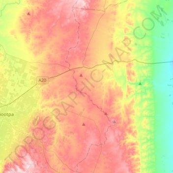
Nombre: Mapa topográfico Truro, altitud, relieve.
Altitud media: 320 m
Altitud mínima: 121 m
Altitud máxima: 518 m
Haz una donación
Equípate para tu próxima aventura:
Como asociado de Amazon, este sitio gana comisiones por las compras que califican, sin ningún costo adicional para usted.