
Mapa topográfico Peasleeville
Mapa interactivo
Haga clic en el mapa para ver la altitud.
Acerca de este mapa
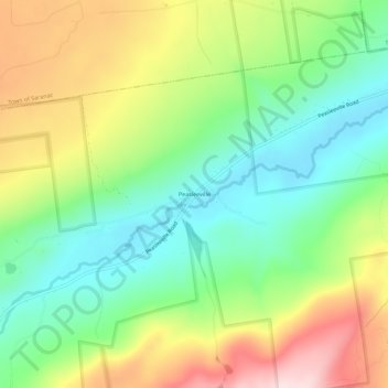
Nombre: Mapa topográfico Peasleeville, altitud, relieve.
Altitud media: 337 m
Altitud mínima: 198 m
Altitud máxima: 551 m
Otros mapas topográficos
Haga clic en un mapa para ver su topografía, su altitud y su relieve.
Valcour Island
United States > New York > Clinton County > Town of Peru
Valcour Island, Town of Peru, Town of Plattsburgh, Clinton County, New York, United States
Altitud media: 34 m
Valcour
United States > New York > Clinton County > Town of Peru
Valcour, Town of Peru, Clinton County, New York, United States
Altitud media: 39 m
Peru
United States > New York > Clinton County > Town of Peru
Peru, Town of Peru, Clinton County, New York, 12972, United States
Altitud media: 105 m