
Mapa topográfico Konkordiahütte
Mapa interactivo
Haga clic en el mapa para ver la altitud.
Acerca de este mapa
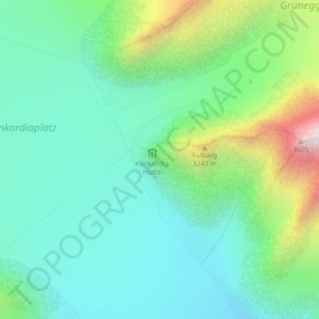
Nombre: Mapa topográfico Konkordiahütte, altitud, relieve.
Lugar: Konkordiahütte, Fieschertal, Goms, Wallis, Schweiz (46.48988 8.04418 46.50988 8.06418)
Altitud media: 2.839 m
Altitud mínima: 2.545 m
Altitud máxima: 3.654 m
Otros mapas topográficos
Haga clic en un mapa para ver su topografía, su altitud y su relieve.
Grosser Aletschgletscher
Schweiz > Wallis > Goms > Fieschertal
Grosser Aletschgletscher, Fieschertal, Goms, Wallis, Schweiz
Altitud media: 2.532 m
Mönch
Schweiz > Wallis > Goms > Fieschertal
Mönch, Fieschertal, Goms, Verwaltungsregion Oberland, Wallis, 3801, Schweiz
Altitud media: 3.392 m
Kranzberg
Schweiz > Wallis > Goms > Fieschertal
Kranzberg, Fieschertal, Goms, Wallis, 3801, Schweiz
Altitud media: 3.403 m
Finsteraarhorn
Schweiz > Wallis > Goms > Fieschertal
Finsteraarhorn, Fieschertal, Goms, Wallis, Schweiz
Altitud media: 3.420 m