
Mapa topográfico Pocatello
Mapa interactivo
Haga clic en el mapa para ver la altitud.
Pocatello
Pocatello is the fifth-largest city in the state, just behind Idaho Falls. In 2007, Pocatello was ranked twentieth on Forbes' list of Best Small Places for Business and Careers. Pocatello is the home of Idaho State University and the manufacturing facility of ON Semiconductor. The city is at an elevation of 4,462 feet (1.360 km) above sea level and is served by the Pocatello Regional Airport.
Acerca de este mapa
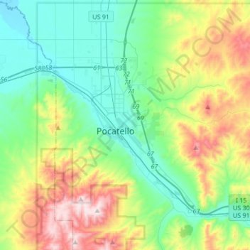
Nombre: Mapa topográfico Pocatello, altitud, relieve.
Lugar: Pocatello, Bannock County, Idaho, United States (42.80215 -112.63186 42.93149 -112.36026)
Altitud media: 1.580 m
Altitud mínima: 1.328 m
Altitud máxima: 2.209 m