
Mapa topográfico Aegean
Mapa interactivo
Haga clic en el mapa para ver la altitud.
Acerca de este mapa
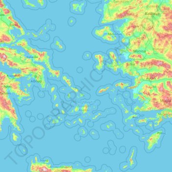
Nombre: Mapa topográfico Aegean, altitud, relieve.
Lugar: Aegean, Greece (35.23795 24.06581 40.10085 29.72970)
Altitud media: 124 m
Altitud mínima: -2 m
Altitud máxima: 2.305 m
Otros mapas topográficos
Haga clic en un mapa para ver su topografía, su altitud y su relieve.
Milos Regional Unit
Milos Regional Unit, South Aegean, Aegean, Greece, Milos
Altitud media: 24 m
Lazarus
Greece > Aegean > Samos Regional Unit > Municipal Unit of Vathy
Lazarus, Municipal Unit of Vathy, Municipality of Eastern Samos, Samos Regional Unit, Northern Aegean, Aegean, Greece
Altitud media: 722 m
Notio Aspronisi West
Notio Aspronisi West, Δήμος Λειψών, Kalmynos Regional Unit, South Aegean Region, Aegean, Greece
Altitud media: 2 m
Panteli
Greece > Aegean > Vromolithos
Panteli, Vromolithos, Δήμος Λέρου, Kalmynos Regional Unit, South Aegean Region, Aegean, 854 00, Greece
Altitud media: 33 m
Thira Municipal Unit
Greece > Aegean > Thira Municipal Unit
Thira Municipal Unit, Δήμος Θήρας, Thira Regional Unit, South Aegean Region, Aegean, Greece
Altitud media: 12 m
Chios
Greece > Aegean > Chios Regional Unit
Chios, Chios Regional Unit, Northern Aegean, Aegean, Greece
Altitud media: 99 m