
Haz una donación
Equípate para tu próxima aventura:
Como asociado de Amazon, este sitio gana comisiones por las compras que califican, sin ningún costo adicional para usted.
Mapa topográfico Chira
Haga clic en el mapa para ver la altitud.
Haz una donación
Equípate para tu próxima aventura:
Como asociado de Amazon, este sitio gana comisiones por las compras que califican, sin ningún costo adicional para usted.
Chira
The southern part of Qira County is mountainous with an average elevation of 3,200 m (10,500 ft) above sea level.[1] The upper reaches of the White Jade River (Yurung Kash), which provide water for Hotan (Khotan), are found in the Kunlun Mountains[1] of southern Qira County.[23] Mountain passes in the area include Mandar Kol Dawan, Shalgon Dawan, Kuchkash Bulak Dawan, and Art Dawan.[23] One of the prominent mountains in the county is Muztag[3][24] (K5,[25] Wu-lu-ko Ho Shan,[10] Mo-shih Shan,[10] Mu-shih Shan,[26] Muztagh Jilga;[23] 慕士山,[27] 木斯山[28]) which is 7,282 m (23,891 ft) above sea level.[3] The meltwater from this mountain creates the Qira River (Cele River, Ts'e-lo Ho;[10] 策勒河[29]) which flows through Qaka into the Qira county seat.[10]
Haz una donación
Equípate para tu próxima aventura:
Como asociado de Amazon, este sitio gana comisiones por las compras que califican, sin ningún costo adicional para usted.
Acerca de este mapa
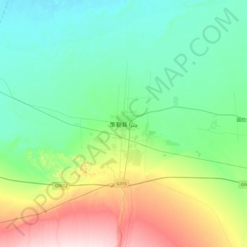
Nombre: Mapa topográfico Chira, altitud, relieve.
Lugar: Chira, Chira County, Hotan Prefecture, Xinjiang, China (36.83979 80.64153 37.15979 80.96153)
Altitud media: 1.406 m
Altitud mínima: 1.313 m
Altitud máxima: 1.669 m
Haz una donación
Equípate para tu próxima aventura:
Como asociado de Amazon, este sitio gana comisiones por las compras que califican, sin ningún costo adicional para usted.