
Haz una donación
Equípate para tu próxima aventura:
Como asociado de Amazon, este sitio gana comisiones por las compras que califican, sin ningún costo adicional para usted.
Mapa topográfico Ishpeming
Haga clic en el mapa para ver la altitud.
Haz una donación
Equípate para tu próxima aventura:
Como asociado de Amazon, este sitio gana comisiones por las compras que califican, sin ningún costo adicional para usted.
Ishpeming
Ishpeming is in central Marquette County, 15 miles (24 km) west of Marquette, the county seat. It is bordered to the east by the city of Negaunee. According to the United States Census Bureau, Ishpeming has a total area of 9.35 square miles (24.22 km2), of which 8.74 square miles (22.64 km2) are land and 0.61 square miles (1.58 km2), or 6.50%, are water. Ishpeming's elevation is 1,436 feet (438 m) above mean sea level, which is over 800 feet (240 m) higher than that of nearby Lake Superior. The highlands of Ishpeming and the surrounding area, including the city of Negaunee to its east, receive an unusually high yearly average of lake-effect snow.
Haz una donación
Equípate para tu próxima aventura:
Como asociado de Amazon, este sitio gana comisiones por las compras que califican, sin ningún costo adicional para usted.
Acerca de este mapa
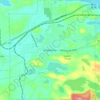
Nombre: Mapa topográfico Ishpeming, altitud, relieve.
Lugar: Ishpeming, Marquette County, Michigan, United States (46.46306 -87.69786 46.51389 -87.63378)
Altitud media: 449 m
Altitud mínima: 411 m
Altitud máxima: 569 m
Haz una donación
Equípate para tu próxima aventura:
Como asociado de Amazon, este sitio gana comisiones por las compras que califican, sin ningún costo adicional para usted.
Otros mapas topográficos
Haga clic en un mapa para ver su topografía, su altitud y su relieve.
Van Riper State Park
United States > Michigan > Marquette County > Michigamme Township
Altitud media: 489 m
Haz una donación
Equípate para tu próxima aventura:
Como asociado de Amazon, este sitio gana comisiones por las compras que califican, sin ningún costo adicional para usted.
Haz una donación
Equípate para tu próxima aventura:
Como asociado de Amazon, este sitio gana comisiones por las compras que califican, sin ningún costo adicional para usted.