
Mapa topográfico Lerwick
Mapa interactivo
Haga clic en el mapa para ver la altitud.
Acerca de este mapa
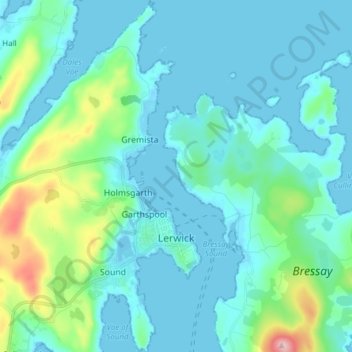
Nombre: Mapa topográfico Lerwick, altitud, relieve.
Lugar: Lerwick, Scotland, United Kingdom (60.12851 -1.21367 60.20441 -1.13170)
Altitud media: 34 m
Altitud mínima: -9 m
Altitud máxima: 225 m
Lerwick has a subpolar oceanic climate (Cfc) with cool to cold temperatures all year long. The lack of trees reflects the latter type. This is particularly pronounced by virtue of Lerwick being on the coast of an island, so even extreme temperature records are subdued; the record high stands at just 23.4 °C (74.1 °F) (July 1991) and the record low just −8.9 °C (16.0 °F) (January 1952 and January 1959). Lerwick is also a very cloudy town, averaging only 1,110 sunshine hours annually. February is the coldest month, with high temperatures averaging around 5.5 °C (41.9 °F). In August, the warmest month, average high temperatures are near 14.5 °C (58.1 °F). This produces an extremely narrow difference for an area north of the 60 parallel. In terms of average monthly precipitation, October to January are the year's wettest months, with over 140 mm (5.5 in) of precipitation each month; May and June are the driest months, with average monthly precipitation less than 60 mm (2.4 in) each. Snowfall can occur, primarily from December to March, but snow accumulation is rarely heavy and usually short-lived. The exposed North Atlantic location and proximity to autumn and winter storm tracks means high winds are a regular occurrence, alongside high levels of cloudiness and precipitation. The weather station is at an elevation of 82 metres (269 ft), so temperatures are likely to be slightly milder in the town centre at sea level.
Otros mapas topográficos
Haga clic en un mapa para ver su topografía, su altitud y su relieve.
Lerwick
United Kingdom > Scotland > Lerwick
Lerwick, Scotland, ZE1 0LU, United Kingdom
Altitud media: 39 m