
Mapa topográfico Prince Rupert
Mapa interactivo
Haga clic en el mapa para ver la altitud.
Prince Rupert
Prince Rupert Airport (YPR/CYPR) is on Digby Island. Its position is 54°17′10″N 130°26′41″W / 54.28611°N 130.44472°W / 54.28611; -130.44472, and its elevation is 35 m (116 ft) above sea level. The airport consists of one runway, one passenger terminal, and two aircraft stands. Access to the airport is typically achieved by a bus connection that departs from downtown Prince Rupert (Highliner Hotel) and travels to Digby Island by ferry. The airport is served by Air Canada from Vancouver International Airport (YVR).
Acerca de este mapa
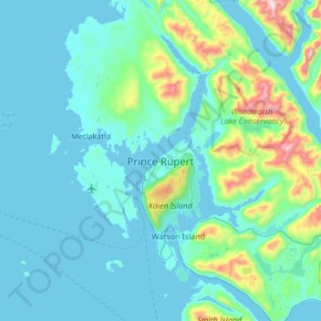
Nombre: Mapa topográfico Prince Rupert, altitud, relieve.
Altitud media: 139 m
Altitud mínima: -1 m
Altitud máxima: 1.164 m