
Mapa topográfico Ranskill
Haga clic en el mapa para ver la altitud.
Acerca de este mapa
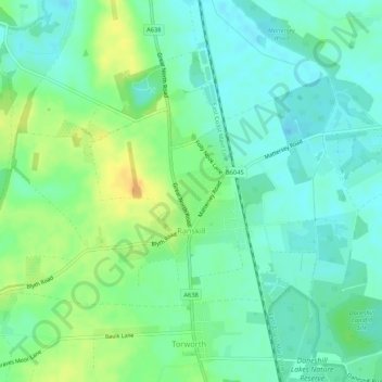
Nombre: Mapa topográfico Ranskill, altitud, relieve.
Altitud media: 15 m
Altitud mínima: 4 m
Altitud máxima: 32 m
Otros mapas topográficos
Haga clic en un mapa para ver su topografía, su altitud y su relieve.
Skegby
United Kingdom > England > Nottinghamshire > Bassetlaw > Normanton on Trent
Altitud media: 18 m
Mattersey Thorpe
United Kingdom > England > Nottinghamshire > Bassetlaw > Mattersey
Altitud media: 12 m
Retford
United Kingdom > England > Nottinghamshire > Bassetlaw
In 1831, the Gas Works was built by James Malam and gaslights were lit in the town for the first time on 22 December 1831. The Square was lit by a cast iron light bearing five gas lamps at that time. The Gas Works became a target on 2 September 1916 when a German Zeppelin dropped 14 bombs on Retford. The…
Altitud media: 31 m
Littleborough
United Kingdom > England > Nottinghamshire > Bassetlaw > Littleborough
Altitud media: 10 m
Walkeringham
United Kingdom > England > Nottinghamshire > Bassetlaw > Walkeringham
Altitud media: 16 m
North Leverton with Habblesthorpe
United Kingdom > England > Nottinghamshire > Bassetlaw
Altitud media: 20 m
South Leverton
United Kingdom > England > Nottinghamshire > Bassetlaw > South Leverton
Altitud media: 22 m