
Mapa topográfico Freihausen
Mapa interactivo
Haga clic en el mapa para ver la altitud.
Acerca de este mapa
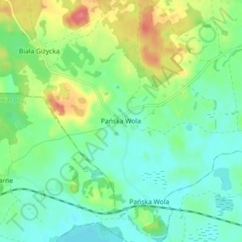
Nombre: Mapa topográfico Freihausen, altitud, relieve.
Altitud media: 140 m
Altitud mínima: 116 m
Altitud máxima: 191 m
Otros mapas topográficos
Haga clic en un mapa para ver su topografía, su altitud y su relieve.
Luisenhof
Polen > Woiwodschaft Ermland-Masuren > Landkreis Lötzen > Siewken
Luisenhof, Siewken, Gemeinde Kruglanken, Landkreis Lötzen, Woiwodschaft Ermland-Masuren, 11-612, Polen
Altitud media: 141 m