
Mapa topográfico Scarborough
Mapa interactivo
Haga clic en el mapa para ver la altitud.
Acerca de este mapa
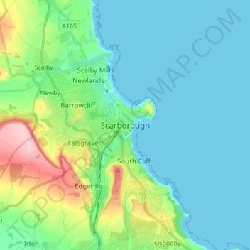
Nombre: Mapa topográfico Scarborough, altitud, relieve.
Altitud media: 39 m
Altitud mínima: -1 m
Altitud máxima: 184 m
The climate is temperate with mild summers and cool, windy, winters. The hottest months of the year are July and August, with temperatures reaching an average high of 17 °C and falling to 11 °C at night. The average daytime temperatures in January are 4 °C, falling to 1 °C at night. The station's elevation of 110 m (360 ft) is far above sea level compared to the immediate coastline, where the climate is likely slightly milder year round.
Otros mapas topográficos
Haga clic en un mapa para ver su topografía, su altitud y su relieve.
Rathmell
United Kingdom > England > North Yorkshire
Rathmell, North Yorkshire, England, BD24 0FG, United Kingdom
Altitud media: 172 m
Osgodby
United Kingdom > England > North Yorkshire
Osgodby, North Yorkshire, England, YO11 3PT, United Kingdom
Altitud media: 43 m
Esk Valley
United Kingdom > England > North Yorkshire > Scarborough > Grosmont
Esk Valley, Grosmont, Scarborough, North Yorkshire, England, YO22 5BG, United Kingdom
Altitud media: 127 m
Whitby
United Kingdom > England > North Yorkshire
Whitby, Scarborough, North Yorkshire, England, United Kingdom
Altitud media: 37 m
Selby
United Kingdom > England > North Yorkshire > Selby
Selby, North Yorkshire, England, United Kingdom
Altitud media: 7 m