
Mapa topográfico Wachenheim an der Weinstraße
Mapa interactivo
Haga clic en el mapa para ver la altitud.
Acerca de este mapa
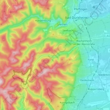
Nombre: Mapa topográfico Wachenheim an der Weinstraße, altitud, relieve.
Altitud media: 202 m
Altitud mínima: 101 m
Altitud máxima: 544 m
Otros mapas topográficos
Haga clic en un mapa para ver su topografía, su altitud y su relieve.
Bad Dürkheim
Germany > Rhineland-Palatinate > Landkreis Bad Dürkheim
Bad Dürkheim, Landkreis Bad Dürkheim, Rhineland-Palatinate, 67098, Germany
Altitud media: 216 m