
Mapa topográfico Mullaghcarn
Mapa interactivo
Haga clic en el mapa para ver la altitud.
Acerca de este mapa
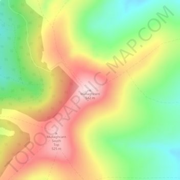
Nombre: Mapa topográfico Mullaghcarn, altitud, relieve.
Altitud media: 386 m
Altitud mínima: 242 m
Altitud máxima: 537 m
Otros mapas topográficos
Haga clic en un mapa para ver su topografía, su altitud y su relieve.
Drumquin
United Kingdom > Northern Ireland > County Tyrone
Drumquin, County Tyrone, Northern Ireland, BT78 4SB, United Kingdom
Altitud media: 97 m
Loughmacrory
United Kingdom > Northern Ireland > County Tyrone > Loughmacrory
Loughmacrory, County Tyrone, Ulster, Northern Ireland, BT79 9LG, United Kingdom
Altitud media: 190 m
Carricknagapple
United Kingdom > Northern Ireland > County Tyrone
Carricknagapple, County Tyrone, Ulster, Northern Ireland, BT79 9AF, United Kingdom
Altitud media: 212 m
Carricknameeltage
United Kingdom > Northern Ireland > County Tyrone
Carricknameeltage, County Tyrone, Ulster, Northern Ireland, BT79 9AF, United Kingdom
Altitud media: 212 m
Rooskey
United Kingdom > Northern Ireland > County Tyrone
Rooskey, County Tyrone, Ulster, Northern Ireland, BT78 3EE, United Kingdom
Altitud media: 133 m
Drumshanbo
United Kingdom > Northern Ireland > County Tyrone
Drumshanbo, County Tyrone, Northern Ireland, BT78 4PT, United Kingdom
Altitud media: 84 m
Claggan
United Kingdom > Northern Ireland > County Tyrone
Claggan, County Tyrone, Ulster, Northern Ireland, United Kingdom
Altitud media: 84 m
Beaghmore
United Kingdom > Northern Ireland > County Tyrone
Beaghmore, Blackrock Road, County Tyrone, Northern Ireland, BT80 9NT, United Kingdom
Altitud media: 190 m
Mulnagore
United Kingdom > Northern Ireland > County Tyrone
Mulnagore, County Tyrone, Ulster, Northern Ireland, United Kingdom
Altitud media: 86 m
Mullaghmenagh
United Kingdom > Northern Ireland > County Tyrone
Mullaghmenagh, County Tyrone, Northern Ireland, United Kingdom
Altitud media: 370 m
Clogh
United Kingdom > Northern Ireland > County Tyrone
Clogh, County Tyrone, Northern Ireland, BT81 7XF, United Kingdom
Altitud media: 205 m
Coagh
United Kingdom > Northern Ireland > County Tyrone > Coagh
Coagh, County Tyrone, Northern Ireland, BT80 0DW, United Kingdom
Altitud media: 43 m
Newtownstewart
United Kingdom > Northern Ireland > County Tyrone > Newtownstewart
Newtownstewart, County Tyrone, Northern Ireland, BT78 4AQ, United Kingdom
Altitud media: 87 m
Castlederg
United Kingdom > Northern Ireland > County Tyrone
Castlederg, County Tyrone, Ulster, Northern Ireland, BT81 7AR, United Kingdom
Altitud media: 78 m
Dungannon
United Kingdom > Northern Ireland > County Tyrone > Dungannon
Dungannon, County Tyrone, Northern Ireland, BT71 7AA, United Kingdom
Altitud media: 76 m
Galbally
United Kingdom > Northern Ireland > County Tyrone
Galbally, County Tyrone, Ulster, Northern Ireland, BT70 2NX, United Kingdom
Altitud media: 119 m
Moy
United Kingdom > Northern Ireland > County Tyrone
Moy, County Tyrone, Northern Ireland, BT71 7SG, United Kingdom
Altitud media: 26 m