
Haz una donación
Equípate para tu próxima aventura:
Como asociado de Amazon, este sitio gana comisiones por las compras que califican, sin ningún costo adicional para usted.
Mapa topográfico Lajatico
Haga clic en el mapa para ver la altitud.
Haz una donación
Equípate para tu próxima aventura:
Como asociado de Amazon, este sitio gana comisiones por las compras que califican, sin ningún costo adicional para usted.
Lajatico
Lajatico is a comune (municipality) in the Province of Pisa in the Italian region Tuscany, located about 50 kilometers (31 mi) southwest of Florence and about 40 kilometers (25 mi) southeast of Pisa. Lajatico sits in mainly hilly terrain at variable elevations from 100 to 650 meters (330 to 2,130 ft) above sea level) and dominates both the end of the Valdera valley and the opening of the valley known as Val di Cecina.
Haz una donación
Equípate para tu próxima aventura:
Como asociado de Amazon, este sitio gana comisiones por las compras que califican, sin ningún costo adicional para usted.
Acerca de este mapa
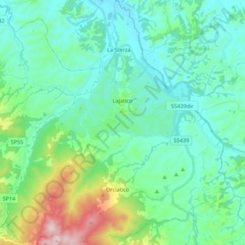
Nombre: Mapa topográfico Lajatico, altitud, relieve.
Lugar: Lajatico, Pisa, Tuscany, Italy (43.40992 10.65520 43.52070 10.79411)
Altitud media: 167 m
Altitud mínima: 46 m
Altitud máxima: 642 m
Haz una donación
Equípate para tu próxima aventura:
Como asociado de Amazon, este sitio gana comisiones por las compras que califican, sin ningún costo adicional para usted.