
Mapa topográfico Haslemere
Haga clic en el mapa para ver la altitud.
Haslemere
Many of the roads in the area originated as medieval tracks and owing to the local topography, are narrow, twisting and steep. The principal route through Haslemere is the A286, which connects the town with Godalming and Grayswood (to the north) and with Midhurst (to the south). The A287 runs south from Hindhead and passes through the west end of Shottermill, before joining the A286 close to Camelsdale. The main east–west road is the B2131, which links Haslemere to Chiddingfold and Petworth to the east, and to Liphook to the west.
Acerca de este mapa
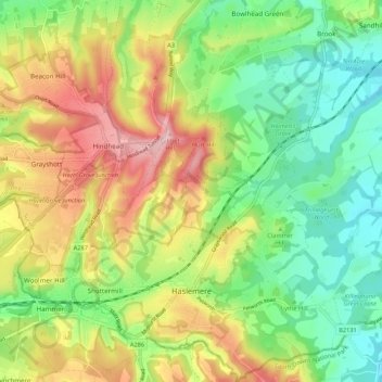
Nombre: Mapa topográfico Haslemere, altitud, relieve.
Lugar: Haslemere, Waverley, Surrey, England, United Kingdom (51.07150 -0.78090 51.13905 -0.67473)
Altitud media: 150 m
Altitud mínima: 65 m
Altitud máxima: 273 m
Otros mapas topográficos
Haga clic en un mapa para ver su topografía, su altitud y su relieve.
Camelsdale
United Kingdom > England > Surrey > Waverley > Haslemere > Shottermill
Altitud media: 166 m
Floodplain (seasonal)
United Kingdom > England > Surrey > Waverley > Farnham > Wrecclesham
Altitud media: 94 m