
Mapa topográfico Budenheim
Mapa interactivo
Haga clic en el mapa para ver la altitud.
Acerca de este mapa
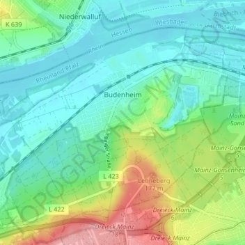
Nombre: Mapa topográfico Budenheim, altitud, relieve.
Altitud media: 113 m
Altitud mínima: 79 m
Altitud máxima: 197 m
Budenheim's greatest elevation is the Lenneberg at 176.8 m, which is in the Lennebergwald. At this spot stands the Lennebergturm (tower), dedicated in 1880 and belonging to the Wander- und Lennebergverein Rheingold Mainz e. V. (a hiking club).
Otros mapas topográficos
Haga clic en un mapa para ver su topografía, su altitud y su relieve.
Ingelheim am Rhein
Germany > Rhineland-Palatinate > Landkreis Mainz-Bingen
Ingelheim am Rhein, Landkreis Mainz-Bingen, Rhineland-Palatinate, Germany
Altitud media: 157 m
Oppenheim
Germany > Rhineland-Palatinate > Landkreis Mainz-Bingen
Oppenheim, Rhein-Selz, Landkreis Mainz-Bingen, Rhineland-Palatinate, 55276, Germany
Altitud media: 121 m