
Mapa topográfico 桃源乡
Mapa interactivo
Haga clic en el mapa para ver la altitud.
Acerca de este mapa
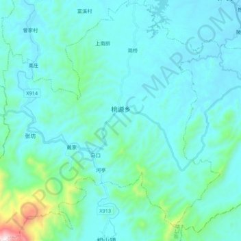
Nombre: Mapa topográfico 桃源乡, altitud, relieve.
Lugar: 桃源乡, 崇仁县, 抚州市, 江西省, 中国 (27.55617 115.94836 27.70246 116.10828)
Altitud media: 184 m
Altitud mínima: 57 m
Altitud máxima: 1.202 m
Otros mapas topográficos
Haga clic en un mapa para ver su topografía, su altitud y su relieve.