
Haz una donación
Equípate para tu próxima aventura:
Como asociado de Amazon, este sitio gana comisiones por las compras que califican, sin ningún costo adicional para usted.
Mapa topográfico Machu Picchu
Haga clic en el mapa para ver la altitud.
Haz una donación
Equípate para tu próxima aventura:
Como asociado de Amazon, este sitio gana comisiones por las compras que califican, sin ningún costo adicional para usted.
Machu Picchu
Animals are also suspected to have immigrated to Machu Picchu as there were several bones found that were not native to the area. Most animal bones found were from llamas and alpacas. These animals naturally live at altitudes of 4,000 metres (13,000 ft) rather than the 2,400 metres (7,900 ft) elevation of Machu Picchu. Most likely, these animals were brought in from the Puna region for meat consumption and for their pelts. Guinea pigs were also found at the site in special burial caves, suggesting that they were at least used for funerary rituals, as it was common throughout the Inca Empire to use them for sacrifices and meat. Six dogs were also recovered from the site. Due to their placements among the human remains, it is believed that they served as companions of the dead.
Haz una donación
Equípate para tu próxima aventura:
Como asociado de Amazon, este sitio gana comisiones por las compras que califican, sin ningún costo adicional para usted.
Acerca de este mapa
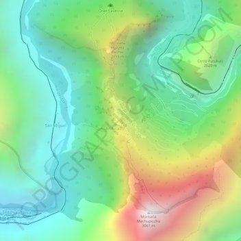
Nombre: Mapa topográfico Machu Picchu, altitud, relieve.
Altitud media: 2.227 m
Altitud mínima: 1.773 m
Altitud máxima: 3.031 m
Haz una donación
Equípate para tu próxima aventura:
Como asociado de Amazon, este sitio gana comisiones por las compras que califican, sin ningún costo adicional para usted.