
Haz una donación
Equípate para tu próxima aventura:
Como asociado de Amazon, este sitio gana comisiones por las compras que califican, sin ningún costo adicional para usted.
Mapa topográfico Hythe End
Haga clic en el mapa para ver la altitud.
Haz una donación
Equípate para tu próxima aventura:
Como asociado de Amazon, este sitio gana comisiones por las compras que califican, sin ningún costo adicional para usted.
Acerca de este mapa
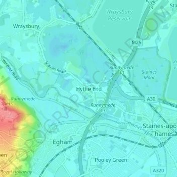
Nombre: Mapa topográfico Hythe End, altitud, relieve.
Altitud media: 21 m
Altitud mínima: 10 m
Altitud máxima: 88 m
Haz una donación
Equípate para tu próxima aventura:
Como asociado de Amazon, este sitio gana comisiones por las compras que califican, sin ningún costo adicional para usted.
Otros mapas topográficos
Haga clic en un mapa para ver su topografía, su altitud y su relieve.
Wraysbury
United Kingdom > England > Royal Borough of Windsor and Maidenhead
The new chapel, with its elegant slender tower, was opened on 16 October 1862; the building works had cost around £800. The striking terracotta relief panel, The City of Refuge, on the front elevation of the chapel, was created by the renowned Doulton & Co artist George Tinworth and is signed with his…
Altitud media: 25 m
Windsor Marina
United Kingdom > England > Royal Borough of Windsor and Maidenhead > Oakley Green
Altitud media: 26 m
Haz una donación
Equípate para tu próxima aventura:
Como asociado de Amazon, este sitio gana comisiones por las compras que califican, sin ningún costo adicional para usted.
Haz una donación
Equípate para tu próxima aventura:
Como asociado de Amazon, este sitio gana comisiones por las compras que califican, sin ningún costo adicional para usted.
Magna Carta Island
United Kingdom > England > Royal Borough of Windsor and Maidenhead > Wraysbury
Altitud media: 32 m
Bridge Gardens
United Kingdom > England > Royal Borough of Windsor and Maidenhead > Maidenhead
Altitud media: 30 m
Haz una donación
Equípate para tu próxima aventura:
Como asociado de Amazon, este sitio gana comisiones por las compras que califican, sin ningún costo adicional para usted.
Upton Court Park
United Kingdom > England > Royal Borough of Windsor and Maidenhead > Slough
Altitud media: 23 m
Formosa Island
United Kingdom > England > Royal Borough of Windsor and Maidenhead > Cookham
Altitud media: 48 m
Windsor Castle
United Kingdom > England > Royal Borough of Windsor and Maidenhead > Windsor > Clewer Village
Altitud media: 23 m
Cox Green
United Kingdom > England > Royal Borough of Windsor and Maidenhead > Maidenhead
Altitud media: 36 m
Haz una donación
Equípate para tu próxima aventura:
Como asociado de Amazon, este sitio gana comisiones por las compras que califican, sin ningún costo adicional para usted.
Horton
United Kingdom > England > Royal Borough of Windsor and Maidenhead > Horton
Altitud media: 18 m
Waltham St. Lawrence
United Kingdom > England > Royal Borough of Windsor and Maidenhead
Altitud media: 44 m
Haz una donación
Equípate para tu próxima aventura:
Como asociado de Amazon, este sitio gana comisiones por las compras que califican, sin ningún costo adicional para usted.
Windsor Castle
United Kingdom > England > Royal Borough of Windsor and Maidenhead > Windsor > Clewer Village
Altitud media: 23 m
Wraysbury
United Kingdom > England > Royal Borough of Windsor and Maidenhead
The new chapel, with its elegant slender tower, was opened on 16 October 1862; the building works had cost around £800. The striking terracotta relief panel, The City of Refuge, on the front elevation of the chapel, was created by the renowned Doulton & Co artist George Tinworth and is signed with his…
Altitud media: 26 m
Haz una donación
Equípate para tu próxima aventura:
Como asociado de Amazon, este sitio gana comisiones por las compras que califican, sin ningún costo adicional para usted.
Windsor Castle
United Kingdom > England > Royal Borough of Windsor and Maidenhead > Windsor > Clewer Village
Altitud media: 23 m
Windsor Castle
United Kingdom > England > Royal Borough of Windsor and Maidenhead > Windsor > Clewer Village
Altitud media: 23 m
Haz una donación
Equípate para tu próxima aventura:
Como asociado de Amazon, este sitio gana comisiones por las compras que califican, sin ningún costo adicional para usted.