
Mapa topográfico Vellore
Mapa interactivo
Haga clic en el mapa para ver la altitud.
Vellore
Vellore is at 12°55′N 79°08′E / 12.92°N 79.13°E / 12.92; 79.13, 220m above sea level. The city has a tropical savanna climate. It is in the Vellore district of the South Indian state, Tamil Nadu, 135 km (84 mi) west of the state capital Chennai and 30 km (19 mi) kms South of its twin city Chittoor, across the Andhra Pradesh border.Vellore lies in the Eastern Ghats region and Palar river basin. The topography is almost flat with slope from west to east.
Acerca de este mapa
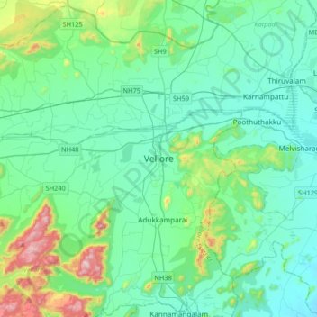
Nombre: Mapa topográfico Vellore, altitud, relieve.
Lugar: Vellore, Tamil Nadu, 632012, India (12.74718 78.97097 13.06718 79.29097)
Altitud media: 283 m
Altitud mínima: 153 m
Altitud máxima: 882 m