
Mapa topográfico Red River
Haga clic en el mapa para ver la altitud.
Acerca de este mapa
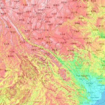
Nombre: Mapa topográfico Red River, altitud, relieve.
Lugar: Red River, China (20.24399 100.09078 25.52934 106.58901)
Altitud media: 1.106 m
Altitud mínima: -1 m
Altitud máxima: 3.220 m
Otros mapas topográficos
Haga clic en un mapa para ver su topografía, su altitud y su relieve.
Chongqing
The central urban area of Chongqing, or Chongqing proper, is a city of unique features. Built on mountains and partially surrounded by the Yangtze and Jialing rivers, it is known as a "mountain city" and a "city on rivers". The night scene of the city is very illuminated, with millions of lights and their…
Altitud media: 318 m
Mount Kailash
China > Tibet > Purang County > Parga town
Mount Kailash (also Kailasa, Gang Tise and Gang Rinpoche or Kangrinboqê) is a mountain in Ngari Prefecture, Tibet Autonomous Region of China. It lies in the Gangdise Shan mountain range of the Transhimalaya, in the western part of the Tibetan Plateau. The peak of Mount Kailash is located at an elevation of…
Altitud media: 5.756 m
Tagong
A gompa is where the Tagong Monastery is located. The gompa is one of the most important in the in Tibetan Pel Lhagong. The Tagong Monastery was established with reference to a nearby sacred mountain, Mt. Yala or Zhara Lhaste, which is 5,820 metres (19,090 ft) in elevation.
Altitud media: 3.874 m
Mount Kailash
China > Tibet > Purang County > Darchen
Mount Kailash (also Kailasa; Kangrinboqê or Gang Rinpoche; Tibetan: གངས་རིན་པོ་ཆེ; simplified Chinese: 冈仁波齐峰; traditional Chinese: 岡仁波齊峰; Sanskrit: कैलास, IAST: Kailāsa), is a mountain in the Ngari Prefecture, Tibet Autonomous Region of China. It has an…
Altitud media: 5.756 m
Xi'an
China > Shaanxi > Weiyang District > Xi'an
Xi'an lies on the Guanzhong Plain in the south-central part of Shaanxi province, on a flood plain created by the eight surrounding rivers and streams. The city has an average elevation of 400 metres (1,312 ft) above sea level and an annual precipitation of 553 mm (21.8 in). The urban area of Xi'an is located…
Altitud media: 412 m
Shanghai
The golden age of Shanghai began with its elevation to municipality on 7 July 1927. This new Chinese municipality covered an area of 494.69 km2 (191.0 sq mi), including the modern-day districts of Baoshan, Yangpu, Zhabei, Nanshi, and Pudong, but excluded the foreign concessions territories. Headed by a Chinese…
Altitud media: 5 m
Shiyan
The far northern and southern reaches of Shiyan are the highest in elevation, while the geographic center of the city has a relatively low elevation. The highest point in Shiyan is Congping in Zhuxi County, at 2,740.2 metres (8,990 ft) above sea level, while the lowest point, Panjiayan in Danjiangkou, is 87…
Altitud media: 422 m
Qaidam Basin
China > Qinghai > Da Qaidam Administrative Zone > Qaidam
Orographically, the Qaidam Basin is a comparatively low area in the northeastern part of the Tibetan Plateau. With an elevation of around 3,000 m (10,000 ft), Qaidam forms a kind of shelf between Tibet to the south (around 4,300 m or 14,000 ft) and Gansu to the north (around 1,100 m or 3,500 ft). A low water…
Altitud media: 2.742 m
K2
China > Xinjiang > Cenling County
K2 is nicknamed "The King of Mountains" and "The Mountaineers' Mountain", as well as "The Mountain of Mountains", a phrase popularized by Italian climber Reinhold Messner in his book on K2. Although the summit of Everest is at a higher altitude, K2 is a more difficult and dangerous climb. This is in part due…
Altitud media: 7.482 m
Mount Makalu
China > Tibet > Tingri County > Qutang town
Makalu (Nepali: मकालु हिमाल, romanized: Makālu himāl; Chinese: 马卡鲁峰; pinyin: Mǎkǎlǔ Fēng) is the fifth-highest mountain on Earth, with a summit at an elevation of 8,485 metres (27,838 ft) AMSL. It is located in the Mahalangur Himalayas 19 km (12 mi) southeast of Mount Everest,…
Altitud media: 7.479 m
Himalayas
The Himalayas, or Himalaya (/ˌhɪməˈleɪ.ə, hɪˈmɑːləjə/ HIM-ə-LAY-ə, hih-MAH-lə-yə), is a mountain range in Asia, separating the plains of the Indian subcontinent from the Tibetan Plateau. The range has some of the Earth's highest peaks, including the highest, Mount Everest. More than 100 peaks…
Altitud media: 2.385 m
Tianjin
The city has 153 km (95 mi) of coastline and 1,137.48 kilometers (706.80 mi) of land border. It is located at the northern end of the Grand Canal of China, which connects with the Yellow and Yangtze Rivers. The municipality is generally flat and is swampy near the coast; however, it has hills in the north,…
Altitud media: 4 m
Victoria Peak
Victoria Peak is a hill on the western half of Hong Kong Island. It is also known as Mount Austin, and locally as The Peak only generally. With an elevation of 552 metres (1,811 ft), it is the tallest hill on Hong Kong Island, and the 29th tallest in the territory of Hong Kong. It is a major tourist attraction…
Altitud media: 209 m
Beijing
Beijing is situated at the northern tip of the roughly triangular North China Plain, which opens to the south and east of the city. Mountains to the north, northwest and west shield the city and northern China's agricultural heartland from the encroaching desert steppes. The northwestern part of the…
Altitud media: 47 m
Broad Peak
China > Xinjiang > Taxkorgan Tajik Autonomous County > Dafdar
Broad Peak is one of the eight-thousanders, and is located in the Karakoram range spanning Gilgit-Baltistan, Pakistan and Xinjiang, China. It is the 12th highest mountain in the world at 8,051 metres (26,414 ft) elevation above sea level. The first ascent of this mountain was in June 1957, accomplished by…
Altitud media: 7.117 m
Himalayas
The Himalayas, or Himalaya, is a mountain range in Asia separating the plains of the Indian subcontinent from the Tibetan Plateau. The range has some of the Earth's highest peaks, including the highest, Mount Everest. More than 100 peaks exceeding elevations of 7,200 m (23,600 ft) above sea level lie in the…
Altitud media: 2.385 m
Mount Makalu
China > Tibet > Tingri County
Makalu (Nepali: मकालु हिमाल, romanized: Makālu himāl; Chinese: 马卡鲁峰; pinyin: Mǎkǎlǔ Fēng) is the fifth-highest mountain on Earth, with a summit at an elevation of 8,485 metres (27,838 ft) AMSL. It is located in the Mahalangur Himalayas 19 km (12 mi) southeast of Mount Everest,…
Altitud media: 7.479 m
Xining
China > Qinghai > Renminjie Subdistrict
The city was a commercial hub along the Northern Silk Road's Hexi Corridor for over 2000 years, and was a stronghold of the Han, Sui, Tang, and Song dynasties' resistance against nomadic attacks from the west. Although long a part of Gansu province, Xining was added to Qinghai in 1928. Xining holds sites of…
Altitud media: 2.505 m
Jiuzhaigou
China > Sichuan > Jiuzhaigou County
The county consists of nine villages in a valley in Sichuan Province. The main ethnic group in the county is Han, with the second being Tibetan. The county seat has an altitude of about 1,400 m (4,600 ft).[1] It has a total area of 2,041 square miles (5,286 km2).[2] As of 2015, the county's total population…
Altitud media: 2.520 m
Zhangjiajie Tianmen Mountain National Forest Park
China > Hunan > Yongding District
Altitud media: 781 m