
Mapa topográfico Chehalis
Mapa interactivo
Haga clic en el mapa para ver la altitud.
Acerca de este mapa
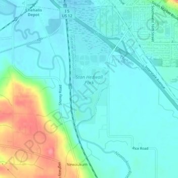
Nombre: Mapa topográfico Chehalis, altitud, relieve.
Altitud media: 67 m
Altitud mínima: 48 m
Altitud máxima: 131 m
Otros mapas topográficos
Haga clic en un mapa para ver su topografía, su altitud y su relieve.
Lewis County
United States > Washington > Lewis County
Lewis County, Washington, United States
Altitud media: 558 m
Chehalis
United States > Washington > Lewis County > Chehalis > Chehalis
Chehalis, Lewis County, Washington, United States
Altitud media: 85 m
Randle
United States > Washington > Lewis County > Randle
Randle, Lewis County, Washington, United States
Altitud media: 378 m