
Haz una donación
Equípate para tu próxima aventura:
Como asociado de Amazon, este sitio gana comisiones por las compras que califican, sin ningún costo adicional para usted.
Mapa topográfico Barnardsville
Haga clic en el mapa para ver la altitud.
Haz una donación
Equípate para tu próxima aventura:
Como asociado de Amazon, este sitio gana comisiones por las compras que califican, sin ningún costo adicional para usted.
Acerca de este mapa
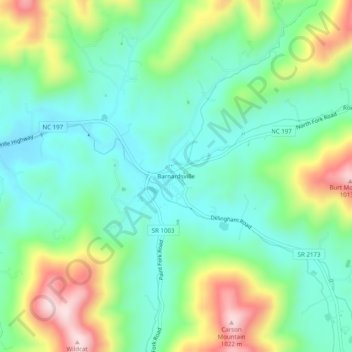
Nombre: Mapa topográfico Barnardsville, altitud, relieve.
Altitud media: 765 m
Altitud mínima: 648 m
Altitud máxima: 1.019 m
Haz una donación
Equípate para tu próxima aventura:
Como asociado de Amazon, este sitio gana comisiones por las compras que califican, sin ningún costo adicional para usted.
Otros mapas topográficos
Haga clic en un mapa para ver su topografía, su altitud y su relieve.
Asheville
United States > North Carolina > Buncombe County
Asheville, located in Buncombe County, North Carolina, is characterized by a diverse and picturesque topography primarily shaped by its position within the Blue Ridge Mountains. The city itself sits at an elevation of approximately 2,200 feet, surrounded by peaks that rise significantly higher, such as Mount…
Altitud media: 727 m
Asheville
United States > North Carolina > Buncombe County
Asheville has a humid subtropical climate (Köppen Cfa), resembling the rest of the Piedmont region of the southeastern U.S., but with noticeably cooler temperatures due to the higher elevation; it is part of USDA Hardiness zone 7a. The area's summers in particular, though warm, are not as hot as summers in…
Altitud media: 727 m
Haz una donación
Equípate para tu próxima aventura:
Como asociado de Amazon, este sitio gana comisiones por las compras que califican, sin ningún costo adicional para usted.
Haw Creek Park
United States > North Carolina > Buncombe County > Asheville > Dogwood Grove
Altitud media: 666 m
Haz una donación
Equípate para tu próxima aventura:
Como asociado de Amazon, este sitio gana comisiones por las compras que califican, sin ningún costo adicional para usted.
Haz una donación
Equípate para tu próxima aventura:
Como asociado de Amazon, este sitio gana comisiones por las compras que califican, sin ningún costo adicional para usted.
Asheville
United States > North Carolina > Buncombe County
Asheville features a climate that borders between a humid subtropical climate (Köppen Cfa/Trewartha Do) and an oceanic climate (Koppen Cfb) with noticeably cooler temperatures than the rest of the Piedmont region of the Southeast due to the higher elevation; it is part of USDA Hardiness zone 7a. The area's…
Altitud media: 727 m
Asheville
United States > North Carolina > Buncombe County
Asheville features a climate that borders between a humid subtropical climate (Köppen: Cfa) and an oceanic climate (Trewartha: Do) with noticeably cooler temperatures than the rest of the Piedmont region of the Southeast due to the higher elevation; it is part of USDA Hardiness zone 7a. The area's summers in…
Altitud media: 727 m
Haz una donación
Equípate para tu próxima aventura:
Como asociado de Amazon, este sitio gana comisiones por las compras que califican, sin ningún costo adicional para usted.
Asheville
United States > North Carolina > Buncombe County
Asheville features a climate that borders between a humid subtropical climate (Köppen: Cfa) and an oceanic climate (Trewartha: Do) with noticeably cooler temperatures than the rest of the Piedmont region of the Southeast due to the higher elevation; it is part of USDA Hardiness zone 7a. The area's summers in…
Altitud media: 727 m
Haz una donación
Equípate para tu próxima aventura:
Como asociado de Amazon, este sitio gana comisiones por las compras que califican, sin ningún costo adicional para usted.
Asheville
United States > North Carolina > Buncombe County
Asheville features a climate that borders between a humid subtropical climate (Köppen Cfa/Trewartha Do) and an oceanic climate (Koppen Cfb) with noticeably cooler temperatures than the rest of the Piedmont region of the Southeast due to the higher elevation; it is part of USDA Hardiness zone 7a. The area's…
Altitud media: 727 m
Haz una donación
Equípate para tu próxima aventura:
Como asociado de Amazon, este sitio gana comisiones por las compras que califican, sin ningún costo adicional para usted.