
Mapa topográfico West Frankfort
Mapa interactivo
Haga clic en el mapa para ver la altitud.
Acerca de este mapa
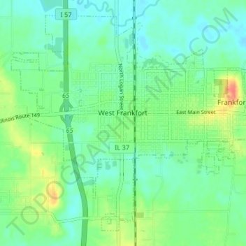
Nombre: Mapa topográfico West Frankfort, altitud, relieve.
Altitud media: 122 m
Altitud mínima: 108 m
Altitud máxima: 155 m
The area of West Frankfort formerly known as Frankfort is still sometimes referred to locally as Frankfort Heights or, more commonly, simply as "The Heights", due to its higher elevation relative to the rest of the city. A post office was maintained in Frankfort Heights until its destruction by fire in 2004, making West Frankfort one of the smallest cities in the United States to have two ZIP codes (the other zip code is designated as "Frankfort Heights, Illinois").
Otros mapas topográficos
Haga clic en un mapa para ver su topografía, su altitud y su relieve.
Benton Park
United States > Illinois > Franklin County > Benton
Benton Park, Benton, Franklin County, Illinois, 62897, United States
Altitud media: 138 m
Benton
United States > Illinois > Franklin County
Benton, Franklin County, Illinois, 62812, United States
Altitud media: 132 m
Christopher
United States > Illinois > Franklin County
Christopher, Franklin County, Illinois, 62822, United States
Altitud media: 130 m
Thompsonville
United States > Illinois > Franklin County
Thompsonville, Franklin County, Illinois, United States
Altitud media: 147 m
Royalton
United States > Illinois > Franklin County > Royalton
Royalton, Franklin County, Illinois, United States
Altitud media: 122 m
Rend Lake
United States > Illinois > Franklin County
Rend Lake, Franklin County, Illinois, United States
Altitud media: 132 m