
Haz una donación
Equípate para tu próxima aventura:
Como asociado de Amazon, este sitio gana comisiones por las compras que califican, sin ningún costo adicional para usted.
Mapa topográfico Setsoto Local Municipality
Haga clic en el mapa para ver la altitud.
Haz una donación
Equípate para tu próxima aventura:
Como asociado de Amazon, este sitio gana comisiones por las compras que califican, sin ningún costo adicional para usted.
Acerca de este mapa
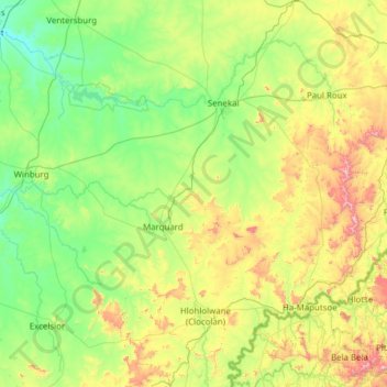
Nombre: Mapa topográfico Setsoto Local Municipality, altitud, relieve.
Altitud media: 1.553 m
Altitud mínima: 1.306 m
Altitud máxima: 2.369 m
Haz una donación
Equípate para tu próxima aventura:
Como asociado de Amazon, este sitio gana comisiones por las compras que califican, sin ningún costo adicional para usted.
Otros mapas topográficos
Haga clic en un mapa para ver su topografía, su altitud y su relieve.
Phuthaditjhaba
South Africa > Free State > Thabo Mofutsanyana District Municipality > Maluti-a-Phofung Local Municipality
Altitud media: 1.736 m
Bethlehem
South Africa > Free State > Thabo Mofutsanyana District Municipality > Dihlabeng Local Municipality
The city lies at an altitude of 1,700 metres (5,600 ft) and this contributes to its cool climate with frosty winters and mild summers. The average annual temperature is around 14 °C (57 °F).
Altitud media: 1.675 m
Fouriesburg
South Africa > Free State > Thabo Mofutsanyana District Municipality > Dihlabeng Local Municipality
Altitud media: 1.745 m
Reitz
South Africa > Free State > Thabo Mofutsanyana District Municipality > Nketoana Local Municipality
Reitz is located in the north-eastern part of the Free State province, 300 kilometres (190 mi) north-east of Bloemfontein and 180 kilometres (110 mi) south of Johannesburg. It lies roughly halfway between the towns of Bethlehem and Frankfort, at an elevation of 1,630 metres (5,350 ft).
Altitud media: 1.648 m
Haz una donación
Equípate para tu próxima aventura:
Como asociado de Amazon, este sitio gana comisiones por las compras que califican, sin ningún costo adicional para usted.
Vrede
South Africa > Free State > Thabo Mofutsanyana District Municipality > Phumelela Local Municipality
Altitud media: 1.678 m
Ficksburg
South Africa > Free State > Thabo Mofutsanyana District Municipality > Setsoto Local Municipality
Altitud media: 1.617 m
Clarens
South Africa > Free State > Thabo Mofutsanyana District Municipality > Dihlabeng Local Municipality
Altitud media: 1.874 m
Mont Pelaan
South Africa > Free State > Thabo Mofutsanyana District Municipality > Phumelela Local Municipality
Altitud media: 1.960 m
Haz una donación
Equípate para tu próxima aventura:
Como asociado de Amazon, este sitio gana comisiones por las compras que califican, sin ningún costo adicional para usted.
Hlohlolwane (Clocolan)
South Africa > Free State > Thabo Mofutsanyana District Municipality > Setsoto Local Municipality
Altitud media: 1.593 m
Ladybrand
South Africa > Free State > Thabo Mofutsanyana District Municipality > Mantsopa Local Municipality
Altitud media: 1.634 m
Renoster River
South Africa > Free State > Thabo Mofutsanyana District Municipality > Nketoana Local Municipality
Altitud media: 1.587 m
Swartkrans
South Africa > Free State > Thabo Mofutsanyana District Municipality > Dihlabeng Local Municipality
Altitud media: 2.036 m
Haz una donación
Equípate para tu próxima aventura:
Como asociado de Amazon, este sitio gana comisiones por las compras que califican, sin ningún costo adicional para usted.
Marquard
South Africa > Free State > Thabo Mofutsanyana District Municipality > Setsoto Local Municipality
Altitud media: 1.512 m
Wilge River
South Africa > Free State > Thabo Mofutsanyana District Municipality > Maluti-a-Phofung Local Municipality
Altitud media: 1.739 m
Koeberg
South Africa > Free State > Thabo Mofutsanyana District Municipality > Dihlabeng Local Municipality
Altitud media: 2.167 m
Mabula
South Africa > Free State > Thabo Mofutsanyana District Municipality > Mantsopa Local Municipality
Altitud media: 1.766 m
Haz una donación
Equípate para tu próxima aventura:
Como asociado de Amazon, este sitio gana comisiones por las compras que califican, sin ningún costo adicional para usted.
Mount Morkel
South Africa > Free State > Thabo Mofutsanyana District Municipality > Dihlabeng Local Municipality
Altitud media: 1.849 m
Bohlokong
South Africa > Free State > Thabo Mofutsanyana District Municipality > Dihlabeng Local Municipality
Altitud media: 1.633 m
Elands River
South Africa > Free State > Thabo Mofutsanyana District Municipality > Maluti-a-Phofung Local Municipality
Altitud media: 1.638 m
Driekloof Dam
South Africa > Free State > Thabo Mofutsanyana District Municipality > Maluti-a-Phofung Local Municipality
Altitud media: 1.743 m
Haz una donación
Equípate para tu próxima aventura:
Como asociado de Amazon, este sitio gana comisiones por las compras que califican, sin ningún costo adicional para usted.
Lindley
South Africa > Free State > Thabo Mofutsanyana District Municipality > Nketoana Local Municipality
Altitud media: 1.540 m
Bethlehem
South Africa > Free State > Thabo Mofutsanyana District Municipality > Dihlabeng Local Municipality
The city lies at an altitude of 1,700 metres (5,600 ft), which contributes to its cool climate, with frosty winters and mild summers. The average annual temperature is around 14 °C (57 °F).
Altitud media: 1.675 m
Sterkfontein Dam
South Africa > Free State > Thabo Mofutsanyana District Municipality > Maluti-a-Phofung Local Municipality
Altitud media: 1.677 m
Ficksburg
South Africa > Free State > Thabo Mofutsanyana District Municipality > Setsoto Local Municipality
Altitud media: 1.617 m
Haz una donación
Equípate para tu próxima aventura:
Como asociado de Amazon, este sitio gana comisiones por las compras que califican, sin ningún costo adicional para usted.
Renoster River
South Africa > Free State > Thabo Mofutsanyana District Municipality > Nketoana Local Municipality > Petrus Steyn
Altitud media: 1.698 m
Paul Roux
South Africa > Free State > Thabo Mofutsanyana District Municipality > Dihlabeng Local Municipality
Altitud media: 1.580 m
Rainfall Dam
South Africa > Free State > Thabo Mofutsanyana District Municipality > Maluti-a-Phofung Local Municipality
Altitud media: 1.707 m
iNtabazwe (Harrismith)
South Africa > Free State > Thabo Mofutsanyana District Municipality > Maluti-a-Phofung Local Municipality
Altitud media: 1.716 m
Haz una donación
Equípate para tu próxima aventura:
Como asociado de Amazon, este sitio gana comisiones por las compras que califican, sin ningún costo adicional para usted.
Reitz
South Africa > Free State > Thabo Mofutsanyana District Municipality > Nketoana Local Municipality
Reitz is located in the north-eastern part of the Free State province, 300 kilometres (190 mi) north-east of Bloemfontein and 180 kilometres (110 mi) south of Johannesburg. It lies roughly halfway between the towns of Bethlehem and Frankfort, at an elevation of 1,630 metres (5,350 ft).
Altitud media: 1.648 m
Petrus Steyn
South Africa > Free State > Thabo Mofutsanyana District Municipality > Nketoana Local Municipality
Altitud media: 1.688 m
Senekal
South Africa > Free State > Thabo Mofutsanyana District Municipality > Setsoto Local Municipality
Altitud media: 1.451 m
Bethlehem
South Africa > Free State > Thabo Mofutsanyana District Municipality > Dihlabeng Local Municipality
The city lies at an altitude of 1,700 metres (5,600 ft) and this contributes to its cool climate with frosty winters and mild summers. The average annual temperature is around 14 °C (57 °F).
Altitud media: 1.675 m
Haz una donación
Equípate para tu próxima aventura:
Como asociado de Amazon, este sitio gana comisiones por las compras que califican, sin ningún costo adicional para usted.
Mabula
South Africa > Free State > Thabo Mofutsanyana District Municipality > Mantsopa Local Municipality
Altitud media: 1.766 m
Marquard
South Africa > Free State > Thabo Mofutsanyana District Municipality > Setsoto Local Municipality
Altitud media: 1.512 m
Bethlehem
South Africa > Free State > Thabo Mofutsanyana District Municipality > Dihlabeng Local Municipality
The city lies at an altitude of 1,700 metres (5,600 ft) and this contributes to its cool climate with frosty winters and mild summers. The average annual temperature is around 14 °C (57 °F).
Altitud media: 1.675 m
Hobhouse
South Africa > Free State > Thabo Mofutsanyana District Municipality > Mantsopa Local Municipality
Altitud media: 1.494 m
Haz una donación
Equípate para tu próxima aventura:
Como asociado de Amazon, este sitio gana comisiones por las compras que califican, sin ningún costo adicional para usted.
Ladybrand
South Africa > Free State > Thabo Mofutsanyana District Municipality > Mantsopa Local Municipality
Altitud media: 1.634 m
Meqheleng
South Africa > Free State > Thabo Mofutsanyana District Municipality > Setsoto Local Municipality
Altitud media: 1.599 m
Hlohlolwane (Clocolan)
South Africa > Free State > Thabo Mofutsanyana District Municipality > Setsoto Local Municipality
Altitud media: 1.593 m
Clarens
South Africa > Free State > Thabo Mofutsanyana District Municipality > Dihlabeng Local Municipality
Altitud media: 1.874 m
Haz una donación
Equípate para tu próxima aventura:
Como asociado de Amazon, este sitio gana comisiones por las compras que califican, sin ningún costo adicional para usted.
Elands River
South Africa > Free State > Thabo Mofutsanyana District Municipality > Maluti-a-Phofung Local Municipality
Altitud media: 1.638 m
Memel
South Africa > Free State > Thabo Mofutsanyana District Municipality > Phumelela Local Municipality
Memel-Zamani lies in the west-facing lee of the Drakensberg escarpment, the escarpment functioning as the continental divide. Its high elevation and close proximity to the escarpment are the major reason for Memel's cold winters. Visitors are frequently surprised by just how cold winter can be in Memel. Added…
Altitud media: 1.723 m
Rainfall Dam
South Africa > Free State > Thabo Mofutsanyana District Municipality > Maluti-a-Phofung Local Municipality
Altitud media: 1.707 m
Fouriesburg
South Africa > Free State > Thabo Mofutsanyana District Municipality > Dihlabeng Local Municipality
Altitud media: 1.745 m
Haz una donación
Equípate para tu próxima aventura:
Como asociado de Amazon, este sitio gana comisiones por las compras que califican, sin ningún costo adicional para usted.
Rainfall Dam
South Africa > Free State > Thabo Mofutsanyana District Municipality > Maluti-a-Phofung Local Municipality
Altitud media: 1.707 m
Phuthaditjhaba
South Africa > Free State > Thabo Mofutsanyana District Municipality > Maluti-a-Phofung Local Municipality
Altitud media: 1.736 m
Rainfall Dam
South Africa > Free State > Thabo Mofutsanyana District Municipality > Maluti-a-Phofung Local Municipality
Altitud media: 1.707 m