
Mapa topográfico Annandale-on-Hudson
Mapa interactivo
Haga clic en el mapa para ver la altitud.
Acerca de este mapa
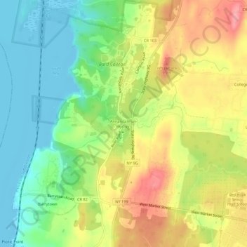
Nombre: Mapa topográfico Annandale-on-Hudson, altitud, relieve.
Altitud media: 43 m
Altitud mínima: -6 m
Altitud máxima: 96 m
Otros mapas topográficos
Haga clic en un mapa para ver su topografía, su altitud y su relieve.
Barrytown
United States > New York > Dutchess County > Town of Red Hook
Barrytown, Town of Red Hook, Dutchess County, New York, 12507, United States
Altitud media: 26 m
Cokertown
United States > New York > Dutchess County > Town of Red Hook
Cokertown, Town of Red Hook, Dutchess County, New York, 12571, United States
Altitud media: 106 m