Geolocalizar

Mapa topográfico Sverdrup Ø

Mapa interactivo

Haga clic en el mapa para ver la altitud.

Acerca de este mapa

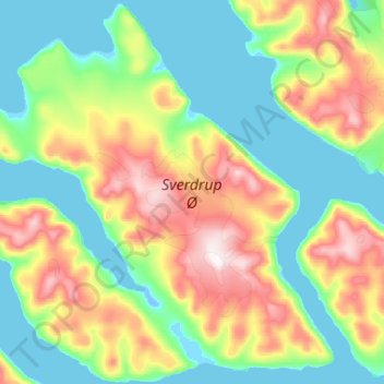
Nombre: Mapa topográfico Sverdrup Ø, altitud, relieve.

Lugar: Sverdrup Ø, Groenlandia (82.78471 -47.66110 83.03876 -45.57656)

Altitud media: 229 m

Altitud mínima: -5 m

Altitud máxima: 1.031 m

Otros mapas topográficos

Haga clic en un mapa para ver su topografía, su altitud y su relieve.

Tour de Pavot

Groenlandia

Tour de Pavot, Groenlandia

Altitud media: 1.787 m

Kujalleq

Groenlandia

Kujalleq, Groenlandia

Altitud media: 784 m

Sermersooq

Groenlandia

Sermersooq, Groenlandia

Altitud media: 1.116 m

Avannaata

Groenlandia

Avannaata, Groenlandia

Altitud media: 1.391 m

Qeqertarsuaq

Groenlandia

Qeqertarsuaq, Qeqertalik, Groenlandia

Altitud media: 424 m

Clavering Ø

Groenlandia

Clavering Ø, Sermersooq, Groenlandia

Altitud media: 381 m

Store Koldewey

Groenlandia

Store Koldewey, Sermersooq, Groenlandia

Altitud media: 40 m

Ymer Ø

Groenlandia

Ymer Ø, Sermersooq, Groenlandia

Altitud media: 622 m

Isla Traill

Groenlandia

Isla Traill, Sermersooq, Groenlandia

Altitud media: 241 m

Milne Land

Groenlandia

Milne Land, Sermersooq, Groenlandia

Altitud media: 39 m

Narsaq

Groenlandia > Narsaq

Narsaq, Kujalleq, 3921, Groenlandia

Altitud media: 117 m

Kuhn Ø

Groenlandia

Kuhn Ø, Sermersooq, Groenlandia

Altitud media: 185 m

Qaanaaq

Groenlandia > Qaanaaq

Qaanaaq, Avannaata, 3971, Groenlandia

Altitud media: 182 m