
Mapa topográfico Pannonhalma
Mapa interactivo
Haga clic en el mapa para ver la altitud.
Acerca de este mapa
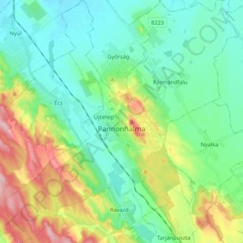
Nombre: Mapa topográfico Pannonhalma, altitud, relieve.
Altitud media: 172 m
Altitud mínima: 119 m
Altitud máxima: 303 m
Otros mapas topográficos
Haga clic en un mapa para ver su topografía, su altitud y su relieve.
Ravazd
Hungría > Győr-Moson-Sopron vármegye
Ravazd, Pannonhalmi járás, Győr-Moson-Sopron vármegye, Transdanubio Occidental, Transdanubia, 9091, Hungría
Altitud media: 207 m
Nyúl
Hungría > Győr-Moson-Sopron vármegye
Nyúl, Győri járás, Győr-Moson-Sopron vármegye, Transdanubio Occidental, Transdanubia, 9082, Hungría
Altitud media: 151 m
Lila-hegy
Hungría > Győr-Moson-Sopron vármegye > Győrújbarát
Lila-hegy, Győrújbarát, Győri járás, Győr-Moson-Sopron vármegye, Transdanubio Occidental, Transdanubia, 9082, Hungría
Altitud media: 217 m
Nyúlhegy
Hungría > Győr-Moson-Sopron vármegye > Nyúl
Nyúlhegy, Nyúl, Győri járás, Győr-Moson-Sopron vármegye, Transdanubio Occidental, Transdanubia, 9082, Hungría
Altitud media: 192 m
Győr
Hungría > Győr-Moson-Sopron vármegye
Győr, Győri járás, Győr-Moson-Sopron vármegye, Transdanubio Occidental, Transdanubia, Hungría
Altitud media: 120 m