
Haz una donación
Equípate para tu próxima aventura:
Como asociado de Amazon, este sitio gana comisiones por las compras que califican, sin ningún costo adicional para usted.
Mapa topográfico Gulf Hills
Haga clic en el mapa para ver la altitud.
Haz una donación
Equípate para tu próxima aventura:
Como asociado de Amazon, este sitio gana comisiones por las compras que califican, sin ningún costo adicional para usted.
Gulf Hills
The terrain in the Bayou Porteaux region is relatively high considering its proximity to the Gulf of Mexico. Elevations range from sea level to 25 feet (7.6 m) above sea level. The area of interest lies south of the Big Ridge escarpment, on the western terminus of an east-west striking coastal ridge, which is sub-parallel to the Big Ridge. Here small bayous and streams have dissected the topography with steep ravines to create a "hilly" terrain. Reconnaissance, surface and geologic investigations indicate that alluvial-fluvial deposits of the Late Pleistocene Prairie Formation are exposed in the higher areas of the Bayou Porteaux-Gulf Hills section.
Haz una donación
Equípate para tu próxima aventura:
Como asociado de Amazon, este sitio gana comisiones por las compras que califican, sin ningún costo adicional para usted.
Acerca de este mapa
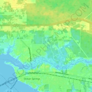
Nombre: Mapa topográfico Gulf Hills, altitud, relieve.
Lugar: Gulf Hills, Jackson County, Mississippi, United States (30.41860 -88.85797 30.45630 -88.77216)
Altitud media: 8 m
Altitud mínima: -2 m
Altitud máxima: 18 m
Haz una donación
Equípate para tu próxima aventura:
Como asociado de Amazon, este sitio gana comisiones por las compras que califican, sin ningún costo adicional para usted.
Otros mapas topográficos
Haga clic en un mapa para ver su topografía, su altitud y su relieve.
Haz una donación
Equípate para tu próxima aventura:
Como asociado de Amazon, este sitio gana comisiones por las compras que califican, sin ningún costo adicional para usted.