
Haz una donación
Equípate para tu próxima aventura:
Como asociado de Amazon, este sitio gana comisiones por las compras que califican, sin ningún costo adicional para usted.
Mapa topográfico Clinton Corners
Haga clic en el mapa para ver la altitud.
Haz una donación
Equípate para tu próxima aventura:
Como asociado de Amazon, este sitio gana comisiones por las compras que califican, sin ningún costo adicional para usted.
Acerca de este mapa
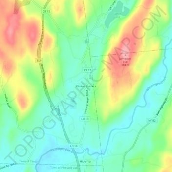
Nombre: Mapa topográfico Clinton Corners, altitud, relieve.
Altitud media: 114 m
Altitud mínima: 71 m
Altitud máxima: 185 m
Haz una donación
Equípate para tu próxima aventura:
Como asociado de Amazon, este sitio gana comisiones por las compras que califican, sin ningún costo adicional para usted.
Otros mapas topográficos
Haga clic en un mapa para ver su topografía, su altitud y su relieve.
Town of Pawling
United States > New York > Dutchess County
The eastern and western section of the towns are high and hilly, with the Great Swamp and Harlem Valley in the middle, where the village of Pawling is located. The highest elevation in town is Observatory Hill, at 1,332 feet (406 m) above sea level; the lowest is 420 feet (130 m), in the Great Swamp, along the…
Altitud media: 243 m
Hillside Lake
United States > New York > Dutchess County > Town of East Fishkill > Hillside Lake
Altitud media: 103 m
Haz una donación
Equípate para tu próxima aventura:
Como asociado de Amazon, este sitio gana comisiones por las compras que califican, sin ningún costo adicional para usted.
Haz una donación
Equípate para tu próxima aventura:
Como asociado de Amazon, este sitio gana comisiones por las compras que califican, sin ningún costo adicional para usted.
Haz una donación
Equípate para tu próxima aventura:
Como asociado de Amazon, este sitio gana comisiones por las compras que califican, sin ningún costo adicional para usted.
Town of North East
United States > New York > Dutchess County
Brace Mountain's 2,311-foot (704 m) summit, near the Connecticut state line in the northeastern corner of town, is the highest point in Dutchess County. The lowest elevation is 530 feet (160 m), along Shekomeko Creek at the Pine Plains town line.
Altitud media: 267 m
Dover Plains
United States > New York > Dutchess County > Dover Plains > Bains Corner
Altitud media: 149 m
Staatsburg
United States > New York > Dutchess County > Town of Hyde Park > Staatsburg
Altitud media: 25 m
City of Poughkeepsie
United States > New York > Dutchess County
According to the United States Census Bureau, the city has an area of 5.7 square miles (14.8 km2), of which 5.1 square miles (13.3 km2) is land, and 0.23 square miles (0.6 km2) (comprising 10.05%) is water. Poughkeepsie lies approximately 75 miles (121 km) north of the center of the New York megacity. It is…
Altitud media: 49 m
Haz una donación
Equípate para tu próxima aventura:
Como asociado de Amazon, este sitio gana comisiones por las compras que califican, sin ningún costo adicional para usted.
Hydepark Recreations
United States > New York > Dutchess County > Town of Hyde Park
Altitud media: 66 m
Haz una donación
Equípate para tu próxima aventura:
Como asociado de Amazon, este sitio gana comisiones por las compras que califican, sin ningún costo adicional para usted.
Town of Fishkill
United States > New York > Dutchess County
According to the United States Census Bureau, the town has a total area of 32.0 square miles (82.9 km2), of which 27.3 square miles (70.8 km2) is land and 4.7 square miles (12.1 km2), or 14.55%, is water. The elevation of the town varies from sea level along the Hudson River (Fishkill Waterfront, Fishkill…
Altitud media: 178 m
Haz una donación
Equípate para tu próxima aventura:
Como asociado de Amazon, este sitio gana comisiones por las compras que califican, sin ningún costo adicional para usted.
City of Poughkeepsie
United States > New York > Dutchess County
According to the United States Census Bureau, the city has an area of 5.7 square miles (14.8 km2), of which 5.1 square miles (13.3 km2) is land, and 0.23 square miles (0.6 km2) (comprising 10.05%) is water. Poughkeepsie lies approximately 75 miles (121 km) north of the center of the New York megacity. It is…
Altitud media: 49 m
Hopewell Junction
United States > New York > Dutchess County > Town of East Fishkill > Hopewell Junction
Altitud media: 83 m
Haz una donación
Equípate para tu próxima aventura:
Como asociado de Amazon, este sitio gana comisiones por las compras que califican, sin ningún costo adicional para usted.
Town of Fishkill
United States > New York > Dutchess County
According to the United States Census Bureau, the town has a total area of 32.0 square miles (82.9 km2), of which 27.3 square miles (70.8 km2) is land and 4.7 square miles (12.1 km2), or 14.55%, is water. The elevation of the town varies from sea level along the Hudson River (Fishkill Waterfront, Fishkill…
Altitud media: 178 m
Haz una donación
Equípate para tu próxima aventura:
Como asociado de Amazon, este sitio gana comisiones por las compras que califican, sin ningún costo adicional para usted.
Haz una donación
Equípate para tu próxima aventura:
Como asociado de Amazon, este sitio gana comisiones por las compras que califican, sin ningún costo adicional para usted.
City of Poughkeepsie
United States > New York > Dutchess County
According to the United States Census Bureau, the city has an area of 5.7 square miles (14.8 km2), of which 5.1 square miles (13.3 km2) is land, and 0.23 square miles (0.6 km2) (comprising 10.05%) is water. Poughkeepsie lies approximately 75 miles (121 km) north of the center of the New York megacity. It is…
Altitud media: 49 m
Haz una donación
Equípate para tu próxima aventura:
Como asociado de Amazon, este sitio gana comisiones por las compras que califican, sin ningún costo adicional para usted.
Town of Pawling
United States > New York > Dutchess County
The eastern and western section of the towns are high and hilly, with the Great Swamp and Harlem Valley in the middle, where the village of Pawling is located. The highest elevation in town is Observatory Hill, at 1,332 feet (406 m) above sea level; the lowest is 420 feet (130 m), in the Great Swamp, along the…
Altitud media: 243 m
Haz una donación
Equípate para tu próxima aventura:
Como asociado de Amazon, este sitio gana comisiones por las compras que califican, sin ningún costo adicional para usted.
Haz una donación
Equípate para tu próxima aventura:
Como asociado de Amazon, este sitio gana comisiones por las compras que califican, sin ningún costo adicional para usted.
Rhinecliff
United States > New York > Dutchess County > Town of Rhinebeck
The hamlet is demarcated by large agricultural and wooded area to the north, east, and south, and bounded by the Hudson River on the west. Steep topography, formed by contorted slate ridges and valleys, define the site-specific and seemingly random orientation of the small, frame nineteenth-century houses and…
Altitud media: 19 m
Haz una donación
Equípate para tu próxima aventura:
Como asociado de Amazon, este sitio gana comisiones por las compras que califican, sin ningún costo adicional para usted.
Hopewell Junction
United States > New York > Dutchess County > Town of East Fishkill > Hopewell Junction
Altitud media: 83 m
Barrytown
United States > New York > Dutchess County > Town of Red Hook > Barrytown
Altitud media: 26 m
Haz una donación
Equípate para tu próxima aventura:
Como asociado de Amazon, este sitio gana comisiones por las compras que califican, sin ningún costo adicional para usted.
Town of North East
United States > New York > Dutchess County
Brace Mountain's 2,311-foot (704 m) summit, near the Connecticut state line in the northeastern corner of town, is the highest point in Dutchess County. The lowest elevation is 530 feet (160 m), along Shekomeko Creek at the Pine Plains town line.
Altitud media: 267 m
Haz una donación
Equípate para tu próxima aventura:
Como asociado de Amazon, este sitio gana comisiones por las compras que califican, sin ningún costo adicional para usted.