Geolocalizar

Mapa topográfico Norton

Haga clic en el mapa para ver la altitud.

Acerca de este mapa

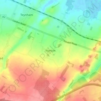
Nombre: Mapa topográfico Norton, altitud, relieve.

Lugar: Norton, Borough of Swale, Kent, England, ME9 9JU, United Kingdom (51.29657 0.80027 51.33657 0.84027)

Altitud media: 35 m

Altitud mínima: -2 m

Altitud máxima: 74 m

Otros mapas topográficos

Haga clic en un mapa para ver su topografía, su altitud y su relieve.

Selling

United Kingdom > England > Kent > Borough of Swale

Altitud media: 64 m

Bobbing

United Kingdom > England > Kent > Borough of Swale

Altitud media: 32 m

Iwade

United Kingdom > England > Kent > Borough of Swale

Altitud media: 6 m

Borden

United Kingdom > England > Kent > Borough of Swale > Borden

Altitud media: 64 m

Oare

United Kingdom > England > Kent > Borough of Swale > Oare

Altitud media: 4 m

Tonge

United Kingdom > England > Kent > Borough of Swale > Bapchild

Altitud media: 23 m

Bredgar

United Kingdom > England > Kent > Borough of Swale

Altitud media: 100 m

Equípate para tu próxima aventura:

🧤Guantes Térmicos Táctiles - Protege tus manos sin dejar de usar tu GPS o móvil
🎯Silbatos de emergencia - Señalización en situaciones críticas
🧤Guantes térmicos - Calor en condiciones frías
🎿Raquetas de Nieve - Explora los mapas nevados sin hundirte
Relojes Deportivos con GPS - Controla tu altitud, posición y ruta directamente en tu muñeca

Como asociado de Amazon, este sitio gana comisiones por las compras que califican, sin ningún costo adicional para usted.