
Haz una donación
Equípate para tu próxima aventura:
Como asociado de Amazon, este sitio gana comisiones por las compras que califican, sin ningún costo adicional para usted.
Mapa topográfico Coachella
Haga clic en el mapa para ver la altitud.
Haz una donación
Equípate para tu próxima aventura:
Como asociado de Amazon, este sitio gana comisiones por las compras que califican, sin ningún costo adicional para usted.
Coachella
The elevation is 68 feet (21 m) below sea level, as the eastern half of the Coachella Valley is below sea level. The saltwater lake, Salton Sea, 10 miles (16 km) south of Coachella, is 228 feet (69 m) below sea level.
Haz una donación
Equípate para tu próxima aventura:
Como asociado de Amazon, este sitio gana comisiones por las compras que califican, sin ningún costo adicional para usted.
Acerca de este mapa
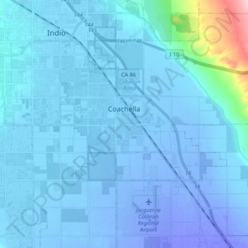
Nombre: Mapa topográfico Coachella, altitud, relieve.
Altitud media: -2 m
Altitud mínima: -48 m
Altitud máxima: 234 m
Haz una donación
Equípate para tu próxima aventura:
Como asociado de Amazon, este sitio gana comisiones por las compras que califican, sin ningún costo adicional para usted.
Otros mapas topográficos
Haga clic en un mapa para ver su topografía, su altitud y su relieve.
Colorado River
United States > California > Riverside County
The entire eastern boundary of the Colorado River Basin runs along the North American Continental Divide and is defined largely by the Rocky Mountains and the Rio Grande Basin. The Wind River Range in Wyoming marks the northern extent of the basin, and is separated from the Colorado Rockies by the endorheic…
Altitud media: 93 m
Haz una donación
Equípate para tu próxima aventura:
Como asociado de Amazon, este sitio gana comisiones por las compras que califican, sin ningún costo adicional para usted.
Idyllwild-Pine Cove
United States > California > Riverside County
"Mile-high Idyllwild" is a mountain resort about one-mile (1,600 m) in altitude. Idyllwild is flanked by two large rock formations, Tahquitz Peak and Suicide Rock (also known as Lily Rock), which are famous in Southern California rock-climbing circles. It offers no skiing, so "the Hill" has been minimally…
Altitud media: 1.746 m