
Mapa topográfico West Albany
Mapa interactivo
Haga clic en el mapa para ver la altitud.
Acerca de este mapa
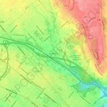
Nombre: Mapa topográfico West Albany, altitud, relieve.
Altitud media: 78 m
Altitud mínima: 29 m
Altitud máxima: 120 m
Otros mapas topográficos
Haga clic en un mapa para ver su topografía, su altitud y su relieve.
Normansville
United States > New York > Albany County > City of Albany
Normansville, City of Albany, Albany County, New York, 12209, United States
Altitud media: 56 m