
Mapa topográfico Novi Pazar
Mapa interactivo
Haga clic en el mapa para ver la altitud.
Novi Pazar
Novi Pazar is located in the valleys of the Jošanica, Raška, Deževska, and Ljudska rivers. It lies at an elevation of 496m, in the southeast Raška region. The city is surrounded by the Golija and Rogozna mountains, and the Pešter plateau lies to the west. The total area of the city administrative area is 742 km². It contains 100 settlements, mostly small and spread over hills and mountains surrounding the city. The largest village is Mur, with over 3000 residents.
Acerca de este mapa
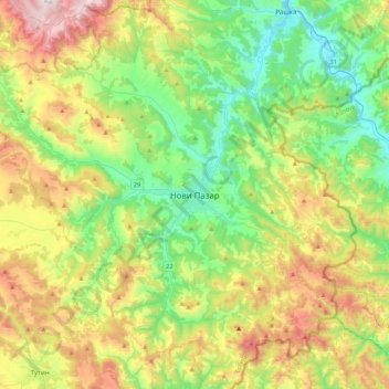
Nombre: Mapa topográfico Novi Pazar, altitud, relieve.
Altitud media: 874 m
Altitud mínima: 400 m
Altitud máxima: 1.781 m