
Mapa topográfico Mapleton
Mapa interactivo
Haga clic en el mapa para ver la altitud.
Acerca de este mapa
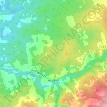
Nombre: Mapa topográfico Mapleton, altitud, relieve.
Altitud media: 102 m
Altitud mínima: 42 m
Altitud máxima: 212 m
Otros mapas topográficos
Haga clic en un mapa para ver su topografía, su altitud y su relieve.
West Amherst
Canada > Nova Scotia > Municipality of the County of Cumberland
West Amherst, Municipality of the County of Cumberland, Cumberland County, Nova Scotia, B4H 3Y4, Canada
Altitud media: 13 m
Westchester
Canada > Nova Scotia > Municipality of the County of Cumberland
Westchester, Municipality of the County of Cumberland, Cumberland County, Nova Scotia, Canada
Altitud media: 157 m
Beckwith
Canada > Nova Scotia > Municipality of the County of Cumberland
Beckwith, Municipality of the County of Cumberland, Cumberland County, Nova Scotia, Canada
Altitud media: 44 m
Northport
Canada > Nova Scotia > Municipality of the County of Cumberland
Northport, Municipality of the County of Cumberland, Cumberland County, Nova Scotia, B0L 1E0, Canada
Altitud media: 12 m
Maccan
Canada > Nova Scotia > Municipality of the County of Cumberland
Maccan, Municipality of the County of Cumberland, Cumberland County, Nova Scotia, B0L 1B0, Canada
Altitud media: 45 m
Parrsboro
Canada > Nova Scotia > Municipality of the County of Cumberland
Parrsboro, Municipality of the County of Cumberland, Cumberland County, Nova Scotia, B0M 1S0, Canada
Altitud media: 25 m
Gulf Shore
Canada > Nova Scotia > Municipality of the County of Cumberland > Gulf Shore
Gulf Shore, Municipality of the County of Cumberland, Cumberland County, Nova Scotia, B0K 1L0, Canada
Altitud media: 11 m